Taebla geodata
Taebla (Lääne) is a seat of a second-order administrative division; located in Estonia in Europe/Tallinn (GMT+3) time zone. With population of 990 people, there are 92 cities with bigger population in this country. Compared to other cities in Estonia, 53.7% of cities are located further ↓South; 92.1% of cities are located further →East and 89.5% of cities have higher elevation than Taebla. Note1


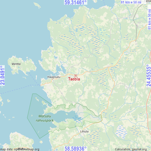
Taebla GPS coordinates[2]
58° 57' 14.004" North, 23° 45' 7.992" East
| Map corner | latitude | longitude |
|---|---|---|
| Upper-left | 59.31461°, | 23.0491° |
| Center: | 58.95389°, | 23.75222° |
| Lower-right: | 58.58936°, | 24.45535° |
| Map W x H: | 80.6×80.6 km | = 50.1×50.1mi |
| max Lat: | 59.57639° ⇑46.3% North |
| Taebla: | 58.95389° |
| min Lat: | ⇓53.7% South 57.72778° |
| min Long | Taebla | max Long |
| 22.24646° | 23.75222° | 28.19028° |
| W 7.9%⇐ | ⇒92.1% E |
Elevation
Elevation of Taebla is 13 m = 43 ft, and this is 40.2 m = 132 ft below average elevation for this country.
| Max E: |
141 m = 463 ft | 89.5% |
| Avg. | 53.2 m = 175 ft | |
| Taebla | 13 m = 43 ft | |
Min E: |
6 m = 20 ft | 10.5% |
See also: Estonia elevation on elevation.city.
Geographical zone
Taebla is located in North temperate zone (between Tropic of Cancer and the Arctic Circle). Distance of this North polar circle is 846.1 km =525.7 mi to North.| Distance of | km | miles | from Taebla |
|---|---|---|---|
| North Pole | 3452 | 2145 | to North |
| Arctic Circle | 846.1 | 525.7 | to North |
| Tropic Cancer | 3949.1 | 2453.9 | to South |
| Equator | 6555.1 | 4073.1 | to South |


Nearby cities:
15 places around Taebla: (largest is in red/bold)
• Haapsalu
12.2 km =7.6 mi,  264°
264°
• Harku
40.6 km =25.2 mi,  60°
60°
• Hullo
29.4 km =18.3 mi,  277°
277°
• Lihula
30.8 km =19.1 mi,  169°
169°
• Märjamaa
39.3 km =24.4 mi,  98°
98°
• Orgita
38.9 km =24.2 mi,  94°
94°
• Paldiski
48 km =29.8 mi,  20°
20°
• Palivere
8.9 km =5.5 mi,  78°
78°
• Riisipere
36.6 km =22.7 mi, 60°
• Risti
44 km =27.3 mi, 173°
• Turba
30.6 km =19 mi, 62°
• Uuemõisa
9.5 km =5.9 mi, 260°
• Vana-Vigala
36.3 km =22.6 mi,  124°
124°
• Vasalemma
44.6 km =27.7 mi,  43°
43°
• Virtsu
44.7 km =27.8 mi,  197°
197°
Sources, notices
• [Note1] Compared only with cities in Estonia existing in our database
• [Src1] Map data: © OpenStreetMap contributors (CC-BY-SA)
• [Src2] Other city data from geonames.org with taken over terms of usage.
• [Src3] Geographical zone / Annual Mean Temperature by Robert A. Rohde @ Wikipedia
