Pärnu geodata
Pärnu (Pärnumaa) is a seat of a first-order administrative division; located in Estonia in Europe/Tallinn (GMT+3) time zone. With population of 44,192 people, there are 4 cities with bigger population in this country. Compared to other cities in Estonia, 71.6% of cities are located further ↑North; 81.1% of cities are located further →East and 100% of cities have higher elevation than Pärnu. Note1


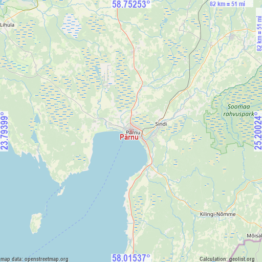
Pärnu GPS coordinates[2]
58° 23' 9.168" North, 24° 29' 49.596" East
| Map corner | latitude | longitude |
|---|---|---|
| Upper-left | 58.75253°, | 23.79399° |
| Center: | 58.38588°, | 24.49711° |
| Lower-right: | 58.01537°, | 25.20024° |
| Map W x H: | 82×82 km | = 51×51mi |
| max Lat: | 59.57639° ⇑71.6% North |
| Pärnu: | 58.38588° |
| min Lat: | ⇓28.4% South 57.72778° |
| min Long | Pärnu | max Long |
| 22.24646° | 24.49711° | 28.19028° |
| W 18.9%⇐ | ⇒81.1% E |
Elevation
Elevation of Pärnu is 6 m = 20 ft, and this is 47.2 m = 155 ft below average elevation for this country.
| Max E: |
141 m = 463 ft | 100% |
| Avg. | 53.2 m = 175 ft | |
| Pärnu | 6 m = 20 ft | |
Min E: |
6 m = 20 ft | 0% |
See also: Pärnu elevation on elevation.city.
Geographical zone
Pärnu is located in North temperate zone (between Tropic of Cancer and the Arctic Circle). Distance of this North polar circle is 909.3 km =565 mi to North.| Distance of | km | miles | from Pärnu |
|---|---|---|---|
| North Pole | 3515.2 | 2184.2 | to North |
| Arctic Circle | 909.3 | 565 | to North |
| Tropic Cancer | 3886 | 2414.6 | to South |
| Equator | 6491.9 | 4033.9 | to South |


Nearby cities:
15 places around Pärnu: (largest is in red/bold)
• Audru
7.6 km =4.7 mi,  289°
289°
• Häädemeeste
33.9 km =21.1 mi,  179°
179°
• Kilingi-Nõmme
37.8 km =23.5 mi,  133°
133°
• Lavassaare
15.3 km =9.5 mi,  335°
335°
• Linaküla
41.2 km =25.6 mi,  227°
227°
• Paikuse
8 km =5 mi,  95°
95°
• Pärnu-Jaagupi
25 km =15.5 mi,  1°
1°
• Sauga
4.6 km =2.9 mi,  358°
358°
• Sindi
10.1 km =6.3 mi,  80°
80°
• Tihemetsa
41.7 km =25.9 mi, 129°
• Tootsi
27.4 km =17 mi,  38°
38°
• Tori
21.7 km =13.5 mi,  61°
61°
• Tõstamaa
29.6 km =18.4 mi,  258°
258°
• Uulu
12.5 km =7.8 mi,  155°
155°
• Võiste
9 km =5.6 mi,  354°
354°
Sources, notices
• [Note1] Compared only with cities in Estonia existing in our database
• [Src1] Map data: © OpenStreetMap contributors (CC-BY-SA)
• [Src2] Other city data from geonames.org with taken over terms of usage.
• [Src3] Geographical zone / Annual Mean Temperature by Robert A. Rohde @ Wikipedia
