Mõisaküla geodata
Mõisaküla (Viljandimaa) is a populated place; located in Estonia in Europe/Tallinn (GMT+3) time zone. With population of 1,090 people, there are 77 cities with bigger population in this country. Compared to other cities in Estonia, 89.5% of cities are located further ↑North; 55.8% of cities are located further →East and 82.1% of cities have lower elevation than Mõisaküla. Note1


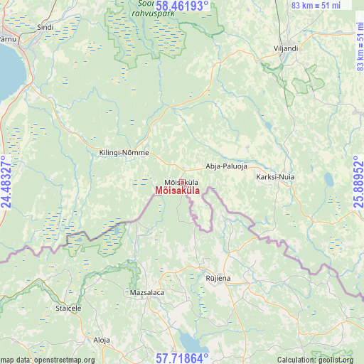
Mõisaküla GPS coordinates[2]
58° 5' 31.992" North, 25° 11' 11.004" East
| Map corner | latitude | longitude |
|---|---|---|
| Upper-left | 58.46193°, | 24.48327° |
| Center: | 58.09222°, | 25.18639° |
| Lower-right: | 57.71864°, | 25.88952° |
| Map W x H: | 82.6×82.6 km | = 51.3×51.3mi |
| max Lat: | 59.57639° ⇑89.5% North |
| Mõisaküla: | 58.09222° |
| min Lat: | ⇓10.5% South 57.72778° |
| min Long | Mõisaküla | max Long |
| 22.24646° | 25.18639° | 28.19028° |
| W 44.2%⇐ | ⇒55.8% E |
Elevation
Elevation of Mõisaküla is 77 m = 253 ft, and this is 23.8 m = 78 ft above average elevation for this country.
| Max E: |
141 m = 463 ft | 17.9% |
| Mõisaküla | 77 m 253 ft | |
| Avg. | 53.2 m = 175 ft | |
Min E: |
6 m = 20 ft | 82.1% |
See also: Estonia elevation on elevation.city.
Geographical zone
Mõisaküla is located in North temperate zone (between Tropic of Cancer and the Arctic Circle). Distance of this North polar circle is 941.9 km =585.3 mi to North.| Distance of | km | miles | from Mõisaküla |
|---|---|---|---|
| North Pole | 3547.8 | 2204.5 | to North |
| Arctic Circle | 941.9 | 585.3 | to North |
| Tropic Cancer | 3853.3 | 2394.3 | to South |
| Equator | 6459.2 | 4013.6 | to South |


Nearby cities:
15 places around Mõisaküla: (largest is in red/bold)
• Abja-Paluoja
10.3 km =6.4 mi,  69°
69°
• Häädemeeste
40.5 km =25.2 mi,  268°
268°
• Karksi
23.7 km =14.7 mi,  83°
83°
• Karksi-Nuia
22.2 km =13.8 mi,  86°
86°
• Kilingi-Nõmme
14.6 km =9.1 mi,  296°
296°
• Mustla
6.9 km =4.3 mi,  312°
312°
• Paikuse
45.4 km =28.2 mi, 314°
• Ramsi
31.3 km =19.4 mi,  40°
40°
• Sindi
45.8 km =28.5 mi,  318°
318°
• Tihemetsa
10.2 km =6.3 mi, 305°
• Tõrva
45.2 km =28.1 mi,  102°
102°
• Uulu
41.1 km =25.5 mi, 301°
• Vana-Võidu
43 km =26.7 mi, 39°
• Viiratsi
39.8 km =24.7 mi, 41°
• Viljandi
38.4 km =23.9 mi, 38°
Sources, notices
• [Note1] Compared only with cities in Estonia existing in our database
• [Src1] Map data: © OpenStreetMap contributors (CC-BY-SA)
• [Src2] Other city data from geonames.org with taken over terms of usage.
• [Src3] Geographical zone / Annual Mean Temperature by Robert A. Rohde @ Wikipedia
