Jõgeva geodata
Jõgeva (Jõgevamaa) is a seat of a first-order administrative division; located in Estonia in Europe/Tallinn (GMT+3) time zone. With population of 6,396 people, there are 19 cities with bigger population in this country. Compared to other cities in Estonia, 54.7% of cities are located further ↑North; 68.9% of cities are located further ←West and 83.7% of cities have lower elevation than Jõgeva. Note1


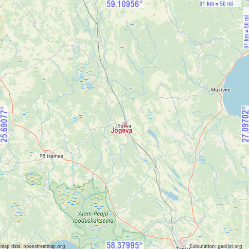
Jõgeva GPS coordinates[2]
58° 44' 48.012" North, 26° 23' 38.004" East
| Map corner | latitude | longitude |
|---|---|---|
| Upper-left | 59.10956°, | 25.69077° |
| Center: | 58.74667°, | 26.39389° |
| Lower-right: | 58.37995°, | 27.09702° |
| Map W x H: | 81.1×81.1 km | = 50.4×50.4mi |
| max Lat: | 59.57639° ⇑54.7% North |
| Jõgeva: | 58.74667° |
| min Lat: | ⇓45.3% South 57.72778° |
| min Long | Jõgeva | max Long |
| 22.24646° | 26.39389° | 28.19028° |
| W 68.9%⇐ | ⇒31.1% E |
Elevation
Elevation of Jõgeva is 79 m = 259 ft, and this is 25.8 m = 85 ft above average elevation for this country.
| Max E: |
141 m = 463 ft | 16.3% |
| Jõgeva | 79 m 259 ft | |
| Avg. | 53.2 m = 175 ft | |
Min E: |
6 m = 20 ft | 83.7% |
See also: Estonia elevation on elevation.city.
Geographical zone
Jõgeva is located in North temperate zone (between Tropic of Cancer and the Arctic Circle). Distance of this North polar circle is 869.2 km =540.1 mi to North.| Distance of | km | miles | from Jõgeva |
|---|---|---|---|
| North Pole | 3475 | 2159.3 | to North |
| Arctic Circle | 869.2 | 540.1 | to North |
| Tropic Cancer | 3926.1 | 2439.6 | to South |
| Equator | 6532 | 4058.8 | to South |


Nearby cities:
15 places around Jõgeva: (largest is in red/bold)
• Adavere
28.9 km =18 mi,  261°
261°
• Avinurme
37.6 km =23.4 mi,  45°
45°
• Ilmatsalu
41 km =25.5 mi,  167°
167°
• Koeru
31.9 km =19.8 mi,  319°
319°
• Kuremaa
7.5 km =4.7 mi,  98°
98°
• Kõrveküla
42.3 km =26.3 mi,  147°
147°
• Mustvee
33.4 km =20.8 mi,  70°
70°
• Palamuse
12.7 km =7.9 mi,  122°
122°
• Puurmani
19.9 km =12.4 mi,  200°
200°
• Põltsamaa
26.6 km =16.5 mi,  246°
246°
• Rakke
27.3 km =17 mi,  342°
342°
• Siimusti
3.7 km =2.3 mi,  239°
239°
• Torma
21.2 km =13.2 mi, 69°
• Väike-Maarja
43 km =26.7 mi,  348°
348°
• Võisiku
30.4 km =18.9 mi, 244°
Sources, notices
• [Note1] Compared only with cities in Estonia existing in our database
• [Src1] Map data: © OpenStreetMap contributors (CC-BY-SA)
• [Src2] Other city data from geonames.org with taken over terms of usage.
• [Src3] Geographical zone / Annual Mean Temperature by Robert A. Rohde @ Wikipedia
