Adavere geodata
Adavere (Jõgevamaa) is a populated place; located in Estonia in Europe/Tallinn (GMT+3) time zone. With population of 646 people, there are 129 cities with bigger population in this country. Compared to other cities in Estonia, 56.3% of cities are located further ↑North; 57.9% of cities are located further ←West and 73.2% of cities have lower elevation than Adavere. Note1


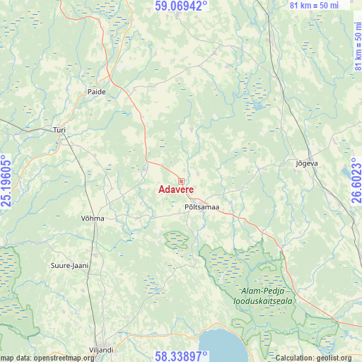
Adavere GPS coordinates[2]
58° 42' 21.996" North, 25° 53' 57.012" East
| Map corner | latitude | longitude |
|---|---|---|
| Upper-left | 59.06942°, | 25.19605° |
| Center: | 58.70611°, | 25.89917° |
| Lower-right: | 58.33897°, | 26.6023° |
| Map W x H: | 81.2×81.2 km | = 50.5×50.5mi |
| max Lat: | 59.57639° ⇑56.3% North |
| Adavere: | 58.70611° |
| min Lat: | ⇓43.7% South 57.72778° |
| min Long | Adavere | max Long |
| 22.24646° | 25.89917° | 28.19028° |
| W 57.9%⇐ | ⇒42.1% E |
Elevation
Elevation of Adavere is 69 m = 226 ft, and this is 15.8 m = 52 ft above average elevation for this country.
| Max E: |
141 m = 463 ft | 26.8% |
| Adavere | 69 m 226 ft | |
| Avg. | 53.2 m = 175 ft | |
Min E: |
6 m = 20 ft | 73.2% |
See also: Estonia elevation on elevation.city.
Geographical zone
Adavere is located in North temperate zone (between Tropic of Cancer and the Arctic Circle). Distance of this North polar circle is 873.7 km =542.9 mi to North.| Distance of | km | miles | from Adavere |
|---|---|---|---|
| North Pole | 3479.6 | 2162.1 | to North |
| Arctic Circle | 873.7 | 542.9 | to North |
| Tropic Cancer | 3921.6 | 2436.8 | to South |
| Equator | 6527.5 | 4056 | to South |


Nearby cities:
15 places around Adavere: (largest is in red/bold)
• Jõgeva
28.9 km =18 mi,  81°
81°
• Koeru
29.6 km =18.4 mi,  14°
14°
• Kuremaa
36.1 km =22.4 mi, 84°
• Olustvere
25.8 km =16 mi,  228°
228°
• Paide
28 km =17.4 mi,  315°
315°
• Puurmani
26 km =16.2 mi,  123°
123°
• Põltsamaa
7.2 km =4.5 mi,  145°
145°
• Siimusti
25.6 km =15.9 mi, 84°
• Suure-Jaani
31.2 km =19.4 mi, 232°
• Särevere
28.7 km =17.8 mi,  288°
288°
• Türi
29.2 km =18.1 mi, 292°
• Türi-Alliku
28.4 km =17.6 mi,  295°
295°
• Vyatsa
32.8 km =20.4 mi,  307°
307°
• Võhma
22.1 km =13.7 mi,  246°
246°
• Võisiku
8.7 km =5.4 mi,  171°
171°
Sources, notices
• [Note1] Compared only with cities in Estonia existing in our database
• [Src1] Map data: © OpenStreetMap contributors (CC-BY-SA)
• [Src2] Other city data from geonames.org with taken over terms of usage.
• [Src3] Geographical zone / Annual Mean Temperature by Robert A. Rohde @ Wikipedia
