Koeru geodata
Koeru (Järvamaa) is a populated place; located in Estonia in Europe/Tallinn (GMT+3) time zone. With population of 1,300 people, there are 71 cities with bigger population in this country. Compared to other cities in Estonia, 54.2% of cities are located further ↓South; 61.1% of cities are located further ←West and 93.7% of cities have lower elevation than Koeru. Note1


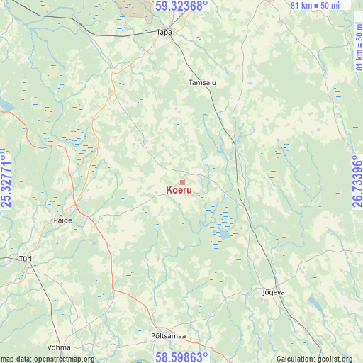
Koeru GPS coordinates[2]
58° 57' 47.016" North, 26° 1' 50.988" East
| Map corner | latitude | longitude |
|---|---|---|
| Upper-left | 59.32368°, | 25.32771° |
| Center: | 58.96306°, | 26.03083° |
| Lower-right: | 58.59863°, | 26.73396° |
| Map W x H: | 80.6×80.6 km | = 50.1×50.1mi |
| max Lat: | 59.57639° ⇑45.8% North |
| Koeru: | 58.96306° |
| min Lat: | ⇓54.2% South 57.72778° |
| min Long | Koeru | max Long |
| 22.24646° | 26.03083° | 28.19028° |
| W 61.1%⇐ | ⇒38.9% E |
Elevation
Elevation of Koeru is 102 m = 335 ft, and this is 48.8 m = 160 ft above average elevation for this country.
| Max E: |
141 m = 463 ft | 6.3% |
| Koeru | 102 m 335 ft | |
| Avg. | 53.2 m = 175 ft | |
Min E: |
6 m = 20 ft | 93.7% |
See also: Estonia elevation on elevation.city.
Geographical zone
Koeru is located in North temperate zone (between Tropic of Cancer and the Arctic Circle). Distance of this North polar circle is 845.1 km =525.1 mi to North.| Distance of | km | miles | from Koeru |
|---|---|---|---|
| North Pole | 3451 | 2144.4 | to North |
| Arctic Circle | 845.1 | 525.1 | to North |
| Tropic Cancer | 3950.2 | 2454.5 | to South |
| Equator | 6556.1 | 4073.8 | to South |


Nearby cities:
15 places around Koeru: (largest is in red/bold)
• Adavere
29.6 km =18.4 mi,  194°
194°
• Aravete
25.1 km =15.6 mi,  322°
322°
• Järva-Jaani
11.8 km =7.3 mi, 315°
• Jõgeva
31.9 km =19.8 mi,  139°
139°
• Kuremaa
37.9 km =23.5 mi,  131°
131°
• Paide
28.5 km =17.7 mi,  252°
252°
• Põltsamaa
34.7 km =21.6 mi, 185°
• Rakke
13 km =8.1 mi,  80°
80°
• Siimusti
31.4 km =19.5 mi,  145°
145°
• Tamsalu
22.3 km =13.9 mi,  12°
12°
• Tapa
33.3 km =20.7 mi,  352°
352°
• Türi-Alliku
37 km =23 mi,  243°
243°
• Vyatsa
34.6 km =21.5 mi,  255°
255°
• Väike-Maarja
22.1 km =13.7 mi,  34°
34°
• Võisiku
37.8 km =23.5 mi, 189°
Sources, notices
• [Note1] Compared only with cities in Estonia existing in our database
• [Src1] Map data: © OpenStreetMap contributors (CC-BY-SA)
• [Src2] Other city data from geonames.org with taken over terms of usage.
• [Src3] Geographical zone / Annual Mean Temperature by Robert A. Rohde @ Wikipedia
