Beheira geodata
Beheira is a seat of a second-order administrative division; located in Egypt in Africa/Cairo (GMT+2) time zone. In our database, there are 135 cities with bigger population. Compared to other cities in Egypt, 58% of cities are located further ↓South; 92.8% of cities are located further →East and 59.4% of cities have lower elevation than Beheira. Note1


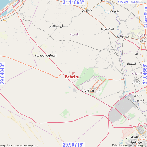
Beheira GPS coordinates[2]
30° 30' 53.208" North, 30° 20' 36.78" East
| Map corner | latitude | longitude |
|---|---|---|
| Upper-left | 31.11863°, | 29.64043° |
| Center: | 30.51478°, | 30.34355° |
| Lower-right: | 29.90716°, | 31.04668° |
| Map W x H: | 134.7×134.7 km | = 83.7×83.7mi |
| max Lat: | 31.5084° ⇑42% North |
| Beheira: | 30.51478° |
| min Lat: | ⇓58% South 22.3457° |
| min Long | Beheira | max Long |
| 25.51965° | 30.34355° | 34.89572° |
| W 7.2%⇐ | ⇒92.8% E |
Elevation
Elevation of Beheira is 23 m = 75 ft, and this is 20.5 m = 67 ft below average elevation for this country.
| Max E: |
1565 m = 5135 ft | 40.6% |
| Avg. | 43.5 m = 143 ft | |
| Beheira | 23 m = 75 ft | |
Min E: |
-15 m = -49 ft | 59.4% |
See also: Egypt elevation on elevation.city.
Geographical zone
Beheira is located in North temperate zone (between Tropic of Cancer and the Arctic Circle). Distance of this Northern Tropic circle is 787 km =489 mi to South.| Distance of | km | miles | from Beheira |
|---|---|---|---|
| North Pole | 6614.1 | 4109.8 | to North |
| Arctic Circle | 4008.2 | 2490.6 | to North |
| Tropic Cancer | 787 | 489 | to South |
| Equator | 3392.9 | 2108.2 | to South |


Nearby cities:
15 places around Beheira: (largest is in red/bold)
• Abū al Maţāmīr
46.8 km =29.1 mi,  339°
339°
• Ad Dilinjāt
39.4 km =24.5 mi,  27°
27°
• Al Bājūr
67.1 km =41.7 mi,  98°
98°
• Ash Shuhadā’
54 km =33.6 mi,  80°
80°
• Ashmūn
65.3 km =40.6 mi,  111°
111°
• Basyūn
65.2 km =40.5 mi,  43°
43°
• Damanhūr
59 km =36.7 mi,  11°
11°
• Kafr ad Dawwār
71.8 km =44.6 mi, 343°
• Kafr az Zayyāt
57 km =35.4 mi,  52°
52°
• Kawm Ḩamādah
43.7 km =27.2 mi, 51°
• Munūf
56.6 km =35.2 mi, 95°
• Shibīn al Kawm
63.9 km =39.7 mi,  86°
86°
• Talā
60.3 km =37.5 mi,  72°
72°
• Tanda
69.9 km =43.4 mi,  64°
64°
• Ḩawsh ‘Īsá
44.5 km =27.7 mi,  353°
353°
Sources, notices
• [Note1] Compared only with cities in Egypt existing in our database
• [Src1] Map data: © OpenStreetMap contributors (CC-BY-SA)
• [Src2] Other city data from geonames.org with taken over terms of usage.
• [Src3] Geographical zone / Annual Mean Temperature by Robert A. Rohde @ Wikipedia
