Tanda geodata
Tanda (Gharbia) is a seat of a first-order administrative division; located in Egypt in Africa/Cairo (GMT+2) time zone. With population of 404,901 people, there are 9 cities with bigger population in this country. Compared to other cities in Egypt, 70.3% of cities are located further ↓South; 68.1% of cities are located further →East and 51.4% of cities have lower elevation than Tanda. Note1


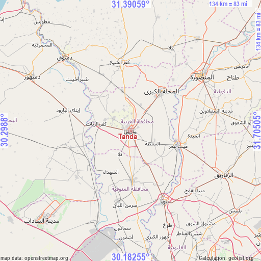
Tanda GPS coordinates[2]
30° 47' 18.492" North, 31° 0' 6.912" East
| Map corner | latitude | longitude |
|---|---|---|
| Upper-left | 31.39059°, | 30.2988° |
| Center: | 30.78847°, | 31.00192° |
| Lower-right: | 30.18255°, | 31.70505° |
| Map W x H: | 134.3×134.3 km | = 83.5×83.5mi |
| max Lat: | 31.5084° ⇑29.7% North |
| Tanda: | 30.78847° |
| min Lat: | ⇓70.3% South 22.3457° |
| min Long | Tanda | max Long |
| 25.51965° | 31.00192° | 34.89572° |
| W 31.9%⇐ | ⇒68.1% E |
Elevation
Elevation of Tanda is 18 m = 59 ft, and this is 25.5 m = 84 ft below average elevation for this country.
| Max E: |
1565 m = 5135 ft | 48.6% |
| Avg. | 43.5 m = 143 ft | |
| Tanda | 18 m = 59 ft | |
Min E: |
-15 m = -49 ft | 51.4% |
See also: Tanda elevation on elevation.city.
Geographical zone
Tanda is located in North temperate zone (between Tropic of Cancer and the Arctic Circle). Distance of this Northern Tropic circle is 817.4 km =507.9 mi to South.| Distance of | km | miles | from Tanda |
|---|---|---|---|
| North Pole | 6583.7 | 4090.9 | to North |
| Arctic Circle | 3977.8 | 2471.7 | to North |
| Tropic Cancer | 817.4 | 507.9 | to South |
| Equator | 3423.4 | 2127.2 | to South |


Nearby cities:
15 places around Tanda: (largest is in red/bold)
• Ajā
32.4 km =20.1 mi,  58°
58°
• Al Bājūr
39.9 km =24.8 mi,  175°
175°
• Al Maḩallah al Kubrá
25.7 km =16 mi,  37°
37°
• Ash Shuhadā’
23.5 km =14.6 mi,  204°
204°
• Basyūn
24.6 km =15.3 mi,  313°
313°
• Kafr ash Shaykh
36.4 km =22.6 mi,  350°
350°
• Kafr az Zayyāt
18 km =11.2 mi,  282°
282°
• Kawm Ḩamādah
29 km =18 mi,  264°
264°
• Munūf
36.5 km =22.7 mi,  190°
190°
• Quwaysinā
29 km =18 mi,  149°
149°
• Quţūr
20.9 km =13 mi, 347°
• Samannūd
29.8 km =18.5 mi,  49°
49°
• Shibīn al Kawm
26.2 km =16.3 mi, 178°
• Talā
13.3 km =8.3 mi, 204°
• Zefta
24.6 km =15.3 mi,  109°
109°
Sources, notices
• [Note1] Compared only with cities in Egypt existing in our database
• [Src1] Map data: © OpenStreetMap contributors (CC-BY-SA)
• [Src2] Other city data from geonames.org with taken over terms of usage.
• [Src3] Geographical zone / Annual Mean Temperature by Robert A. Rohde @ Wikipedia
