Damanhūr geodata
Damanhūr (Beheira) is a seat of a first-order administrative division; located in Egypt in Africa/Cairo (GMT+2) time zone. With population of 227,943 people, there are 17 cities with bigger population in this country. Compared to other cities in Egypt, 79.7% of cities are located further ↓South; 91.3% of cities are located further →East and 86.2% of cities have higher elevation than Damanhūr. Note1


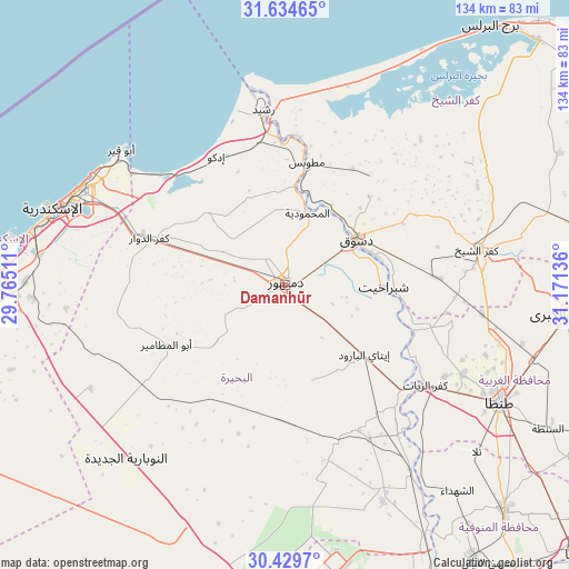
Damanhūr GPS coordinates[2]
31° 2' 2.688" North, 30° 28' 5.628" East
| Map corner | latitude | longitude |
|---|---|---|
| Upper-left | 31.63465°, | 29.76511° |
| Center: | 31.03408°, | 30.46823° |
| Lower-right: | 30.4297°, | 31.17136° |
| Map W x H: | 134×134 km | = 83.3×83.3mi |
| max Lat: | 31.5084° ⇑20.3% North |
| Damanhūr: | 31.03408° |
| min Lat: | ⇓79.7% South 22.3457° |
| min Long | Damanhūr | max Long |
| 25.51965° | 30.46823° | 34.89572° |
| W 8.7%⇐ | ⇒91.3% E |
Elevation
Elevation of Damanhūr is 9 m = 30 ft, and this is 34.5 m = 113 ft below average elevation for this country.
| Max E: |
1565 m = 5135 ft | 86.2% |
| Avg. | 43.5 m = 143 ft | |
| Damanhūr | 9 m = 30 ft | |
Min E: |
-15 m = -49 ft | 13.8% |
See also: Damanhūr elevation on elevation.city.
Geographical zone
Damanhūr is located in North temperate zone (between Tropic of Cancer and the Arctic Circle). Distance of this Northern Tropic circle is 844.7 km =524.9 mi to South.| Distance of | km | miles | from Damanhūr |
|---|---|---|---|
| North Pole | 6556.4 | 4074 | to North |
| Arctic Circle | 3950.5 | 2454.7 | to North |
| Tropic Cancer | 844.7 | 524.9 | to South |
| Equator | 3450.7 | 2144.2 | to South |


Nearby cities:
15 places around Damanhūr: (largest is in red/bold)
• Abū al Maţāmīr
31.2 km =19.4 mi,  243°
243°
• Ad Dilinjāt
23.8 km =14.8 mi,  164°
164°
• Basyūn
34.5 km =21.4 mi,  107°
107°
• Disūq
20.3 km =12.6 mi,  57°
57°
• Fuwwah
20.4 km =12.7 mi,  22°
22°
• Idkū
34.4 km =21.4 mi,  331°
331°
• Kafr ad Dawwār
34.1 km =21.2 mi,  288°
288°
• Kafr ash Shaykh
45.7 km =28.4 mi,  79°
79°
• Kafr az Zayyāt
40.7 km =25.3 mi,  124°
124°
• Kawm Ḩamādah
37.5 km =23.3 mi,  143°
143°
• Munshāt ‘Alī Āghā
26.2 km =16.3 mi, 58°
• Quţūr
47 km =29.2 mi,  98°
98°
• Rosetta
40.9 km =25.4 mi,  353°
353°
• Sīdī Sālim
40.1 km =24.9 mi,  48°
48°
• Ḩawsh ‘Īsá
21.7 km =13.5 mi,  231°
231°
Sources, notices
• [Note1] Compared only with cities in Egypt existing in our database
• [Src1] Map data: © OpenStreetMap contributors (CC-BY-SA)
• [Src2] Other city data from geonames.org with taken over terms of usage.
• [Src3] Geographical zone / Annual Mean Temperature by Robert A. Rohde @ Wikipedia
