Qalyūb geodata
Qalyūb (Qalyubia) is a populated place; located in Egypt in Africa/Cairo (GMT+2) time zone. With population of 100,495 people, there are 37 cities with bigger population in this country. Compared to other cities in Egypt, 50% of cities are located further ↓South; 56.5% of cities are located further →East and 58.7% of cities have lower elevation than Qalyūb. Note1


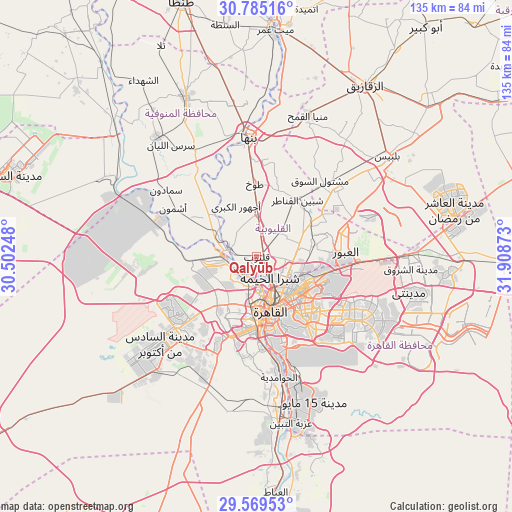
Qalyūb GPS coordinates[2]
30° 10' 45.192" North, 31° 12' 20.16" East
| Map corner | latitude | longitude |
|---|---|---|
| Upper-left | 30.78516°, | 30.50248° |
| Center: | 30.17922°, | 31.2056° |
| Lower-right: | 29.56953°, | 31.90873° |
| Map W x H: | 135.2×135.2 km | = 84×84mi |
| max Lat: | 31.5084° ⇑50% North |
| Qalyūb: | 30.17922° |
| min Lat: | ⇓50% South 22.3457° |
| min Long | Qalyūb | max Long |
| 25.51965° | 31.2056° | 34.89572° |
| W 43.5%⇐ | ⇒56.5% E |
Elevation
Elevation of Qalyūb is 22 m = 72 ft, and this is 21.5 m = 71 ft below average elevation for this country.
| Max E: |
1565 m = 5135 ft | 41.3% |
| Avg. | 43.5 m = 143 ft | |
| Qalyūb | 22 m = 72 ft | |
Min E: |
-15 m = -49 ft | 58.7% |
See also: Qalyūb elevation on elevation.city.
Geographical zone
Qalyūb is located in North temperate zone (between Tropic of Cancer and the Arctic Circle). Distance of this Northern Tropic circle is 749.7 km =465.8 mi to South.| Distance of | km | miles | from Qalyūb |
|---|---|---|---|
| North Pole | 6651.4 | 4133 | to North |
| Arctic Circle | 4045.6 | 2513.8 | to North |
| Tropic Cancer | 749.7 | 465.8 | to South |
| Equator | 3355.6 | 2085.1 | to South |


Nearby cities:
15 places around Qalyūb: (largest is in red/bold)
• Al Bājūr
32.3 km =20.1 mi,  329°
329°
• Al Khānkah
16 km =9.9 mi,  77°
77°
• Al Qanāţir al Khayrīyah
6.8 km =4.2 mi,  283°
283°
• Al Ḩawāmidīyah
31.3 km =19.4 mi,  172°
172°
• Ashmūn
25.6 km =15.9 mi,  300°
300°
• Awsīm
9.2 km =5.7 mi,  227°
227°
• Banhā
31.3 km =19.4 mi,  356°
356°
• Cairo
13.6 km =8.5 mi,  161°
161°
• Giza
19 km =11.8 mi,  178°
178°
• Mashtūl as Sūq
26.1 km =16.2 mi,  39°
39°
• Munūf
41.3 km =25.7 mi,  320°
320°
• New Cairo
30.4 km =18.9 mi,  123°
123°
• Shibīn al Qanāṭir
18.5 km =11.5 mi, 36°
• Toukh
19.5 km =12.1 mi, 358°
• Ḩalwān
38.7 km =24 mi, 166°
Sources, notices
• [Note1] Compared only with cities in Egypt existing in our database
• [Src1] Map data: © OpenStreetMap contributors (CC-BY-SA)
• [Src2] Other city data from geonames.org with taken over terms of usage.
• [Src3] Geographical zone / Annual Mean Temperature by Robert A. Rohde @ Wikipedia
