Toukh geodata
Toukh (Qalyubia) is a populated place; located in Egypt in Africa/Cairo (GMT+2) time zone. With population of 67,599 people, there are 58 cities with bigger population in this country. Compared to other cities in Egypt, 53.6% of cities are located further ↓South; 58% of cities are located further →East and 55.1% of cities have higher elevation than Toukh. Note1


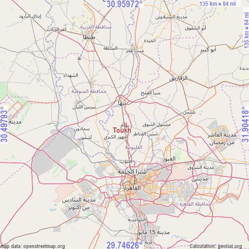
Toukh GPS coordinates[2]
30° 21' 17.532" North, 31° 12' 3.78" East
| Map corner | latitude | longitude |
|---|---|---|
| Upper-left | 30.95972°, | 30.49793° |
| Center: | 30.35487°, | 31.20105° |
| Lower-right: | 29.74626°, | 31.90418° |
| Map W x H: | 134.9×134.9 km | = 83.8×83.8mi |
| max Lat: | 31.5084° ⇑46.4% North |
| Toukh: | 30.35487° |
| min Lat: | ⇓53.6% South 22.3457° |
| min Long | Toukh | max Long |
| 25.51965° | 31.20105° | 34.89572° |
| W 42%⇐ | ⇒58% E |
Elevation
Elevation of Toukh is 16 m = 52 ft, and this is 27.5 m = 90 ft below average elevation for this country.
| Max E: |
1565 m = 5135 ft | 55.1% |
| Avg. | 43.5 m = 143 ft | |
| Toukh | 16 m = 52 ft | |
Min E: |
-15 m = -49 ft | 44.9% |
See also: Toukh elevation on elevation.city.
Geographical zone
Toukh is located in North temperate zone (between Tropic of Cancer and the Arctic Circle). Distance of this Northern Tropic circle is 769.2 km =478 mi to South.| Distance of | km | miles | from Toukh |
|---|---|---|---|
| North Pole | 6631.9 | 4120.9 | to North |
| Arctic Circle | 4026 | 2501.6 | to North |
| Tropic Cancer | 769.2 | 478 | to South |
| Equator | 3375.1 | 2097.2 | to South |


Nearby cities:
15 places around Toukh: (largest is in red/bold)
• Al Bājūr
17.9 km =11.1 mi,  298°
298°
• Al Khānkah
22.7 km =14.1 mi,  135°
135°
• Al Qanāyāt
38.6 km =24 mi,  40°
40°
• Al Qanāţir al Khayrīyah
19 km =11.8 mi,  198°
198°
• Ashmūn
22.5 km =14 mi,  253°
253°
• Awsīm
26.5 km =16.5 mi,  193°
193°
• Banhā
11.8 km =7.3 mi,  352°
352°
• Bilbays
35.4 km =22 mi,  78°
78°
• Cairo
32.8 km =20.4 mi,  171°
171°
• Mashtūl as Sūq
17 km =10.6 mi,  87°
87°
• Munūf
28.6 km =17.8 mi, 295°
• Qalyūb
19.5 km =12.1 mi,  178°
178°
• Quwaysinā
23.7 km =14.7 mi, 349°
• Shibīn al Kawm
28.7 km =17.8 mi,  320°
320°
• Shibīn al Qanāṭir
12.4 km =7.7 mi,  112°
112°
Sources, notices
• [Note1] Compared only with cities in Egypt existing in our database
• [Src1] Map data: © OpenStreetMap contributors (CC-BY-SA)
• [Src2] Other city data from geonames.org with taken over terms of usage.
• [Src3] Geographical zone / Annual Mean Temperature by Robert A. Rohde @ Wikipedia
