Giza geodata
Giza is a seat of a first-order administrative division; located in Egypt in Africa/Cairo (GMT+2) time zone. With population of 2,443,203 people, there are 2 cities with bigger population in this country. Compared to other cities in Egypt, 52.9% of cities are located further ↑North; 55.8% of cities are located further →East and 68.1% of cities have lower elevation than Giza. Note1


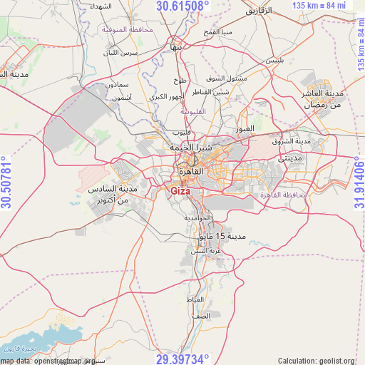
Giza GPS coordinates[2]
30° 0' 29.088" North, 31° 12' 39.348" East
| Map corner | latitude | longitude |
|---|---|---|
| Upper-left | 30.61508°, | 30.50781° |
| Center: | 30.00808°, | 31.21093° |
| Lower-right: | 29.39734°, | 31.91406° |
| Map W x H: | 135.4×135.4 km | = 84.1×84.1mi |
| max Lat: | 31.5084° ⇑52.9% North |
| Giza: | 30.00808° |
| min Lat: | ⇓47.1% South 22.3457° |
| min Long | Giza | max Long |
| 25.51965° | 31.21093° | 34.89572° |
| W 44.2%⇐ | ⇒55.8% E |
Elevation
Elevation of Giza is 30 m = 98 ft, and this is 13.5 m = 44 ft below average elevation for this country.
| Max E: |
1565 m = 5135 ft | 31.9% |
| Avg. | 43.5 m = 143 ft | |
| Giza | 30 m = 98 ft | |
Min E: |
-15 m = -49 ft | 68.1% |
See also: Giza elevation on elevation.city.
Geographical zone
Giza is located in North temperate zone (between Tropic of Cancer and the Arctic Circle). Distance of this Northern Tropic circle is 730.7 km =454 mi to South.| Distance of | km | miles | from Giza |
|---|---|---|---|
| North Pole | 6670.5 | 4144.9 | to North |
| Arctic Circle | 4064.6 | 2525.6 | to North |
| Tropic Cancer | 730.7 | 454 | to South |
| Equator | 3336.6 | 2073.3 | to South |


Nearby cities:
15 places around Giza: (largest is in red/bold)
• Al Khānkah
27.1 km =16.8 mi,  33°
33°
• Al Qanāţir al Khayrīyah
21.8 km =13.5 mi,  340°
340°
• Al Ḩawāmidīyah
12.6 km =7.8 mi,  162°
162°
• Al ‘Ayyāţ
43.4 km =27 mi,  174°
174°
• Ashmūn
39.3 km =24.4 mi,  324°
324°
• Awsīm
14.7 km =9.1 mi,  330°
330°
• Aş Şaff
49.8 km =30.9 mi, 172°
• Cairo
7.1 km =4.4 mi, 31°
• Madīnat Sittah Uktūbar
26.3 km =16.3 mi,  216°
216°
• Mashtūl as Sūq
42.3 km =26.3 mi,  22°
22°
• New Cairo
25.1 km =15.6 mi,  84°
84°
• Qalyūb
19 km =11.8 mi,  358°
358°
• Shibīn al Qanāṭir
35.5 km =22.1 mi, 17°
• Toukh
38.6 km =24 mi, 358°
• Ḩalwān
20.5 km =12.7 mi,  154°
154°
Sources, notices
• [Note1] Compared only with cities in Egypt existing in our database
• [Src1] Map data: © OpenStreetMap contributors (CC-BY-SA)
• [Src2] Other city data from geonames.org with taken over terms of usage.
• [Src3] Geographical zone / Annual Mean Temperature by Robert A. Rohde @ Wikipedia
