Cairo geodata
Cairo is a capital of a political entity; located in Egypt in Africa/Cairo (GMT+2) time zone. With population of 7,734,614 people, there are 0 cities with bigger population in this country. Compared to other cities in Egypt, 51.4% of cities are located further ↑North; 53.6% of cities are located further →East and 59.4% of cities have lower elevation than Cairo. Note1


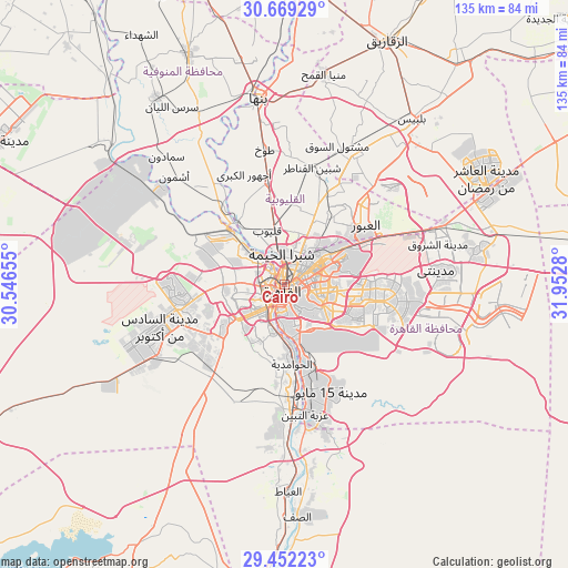
Cairo GPS coordinates[2]
30° 3' 45.468" North, 31° 14' 58.812" East
| Map corner | latitude | longitude |
|---|---|---|
| Upper-left | 30.66929°, | 30.54655° |
| Center: | 30.06263°, | 31.24967° |
| Lower-right: | 29.45223°, | 31.9528° |
| Map W x H: | 135.3×135.3 km | = 84.1×84.1mi |
| max Lat: | 31.5084° ⇑51.4% North |
| Cairo: | 30.06263° |
| min Lat: | ⇓48.6% South 22.3457° |
| min Long | Cairo | max Long |
| 25.51965° | 31.24967° | 34.89572° |
| W 46.4%⇐ | ⇒53.6% E |
Elevation
Elevation of Cairo is 23 m = 75 ft, and this is 20.5 m = 67 ft below average elevation for this country.
| Max E: |
1565 m = 5135 ft | 40.6% |
| Avg. | 43.5 m = 143 ft | |
| Cairo | 23 m = 75 ft | |
Min E: |
-15 m = -49 ft | 59.4% |
See also: Cairo elevation on elevation.city.
Geographical zone
Cairo is located in North temperate zone (between Tropic of Cancer and the Arctic Circle). Distance of this Northern Tropic circle is 736.7 km =457.8 mi to South.| Distance of | km | miles | from Cairo |
|---|---|---|---|
| North Pole | 6664.4 | 4141.1 | to North |
| Arctic Circle | 4058.5 | 2521.8 | to North |
| Tropic Cancer | 736.7 | 457.8 | to South |
| Equator | 3342.7 | 2077.1 | to South |


Nearby cities:
15 places around Cairo: (largest is in red/bold)
• Al Bājūr
45.7 km =28.4 mi,  333°
333°
• Al Khānkah
20 km =12.4 mi,  34°
34°
• Al Qanāţir al Khayrīyah
18.1 km =11.2 mi,  323°
323°
• Al Ḩawāmidīyah
18.1 km =11.2 mi,  179°
179°
• Ashmūn
37 km =23 mi,  314°
314°
• Awsīm
12.9 km =8 mi,  301°
301°
• Banhā
44.6 km =27.7 mi,  351°
351°
• Giza
7.1 km =4.4 mi,  211°
211°
• Madīnat Sittah Uktūbar
33.4 km =20.8 mi,  215°
215°
• Mashtūl as Sūq
35.3 km =21.9 mi,  20°
20°
• New Cairo
21.5 km =13.4 mi,  99°
99°
• Qalyūb
13.6 km =8.5 mi,  341°
341°
• Shibīn al Qanāṭir
28.6 km =17.8 mi,  13°
13°
• Toukh
32.8 km =20.4 mi, 351°
• Ḩalwān
25.1 km =15.6 mi,  168°
168°
In other languages:
- In Spanish: El Cairo
- In France: Le Caire
- In German: Kairo
- In Italian: Il Cairo
- In Russian: Каир
Sources, notices
• [Note1] Compared only with cities in Egypt existing in our database
• [Src1] Map data: © OpenStreetMap contributors (CC-BY-SA)
• [Src2] Other city data from geonames.org with taken over terms of usage.
• [Src3] Geographical zone / Annual Mean Temperature by Robert A. Rohde @ Wikipedia
