Zorita geodata
Zorita (Extremadura) is a seat of a third-order administrative division; located in Spain in Europe/Madrid (GMT+2) time zone. With population of 1,779 people, there are 2299 cities with bigger population in this country. Compared to other cities in Spain, 78.6% of cities are located further ↑North; 81.8% of cities are located further →East and 67.3% of cities have higher elevation than Zorita. Note1


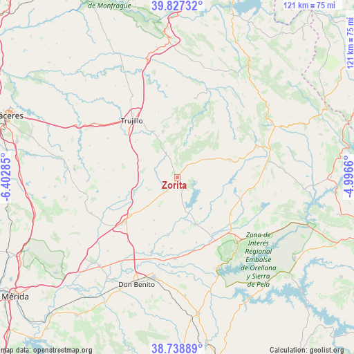
Zorita GPS coordinates[2]
39° 17' 6.792" North, 5° 41' 59.028" West
| Map corner | latitude | longitude |
|---|---|---|
| Upper-left | 39.82732°, | -6.40285° |
| Center: | 39.28522°, | -5.69973° |
| Lower-right: | 38.73889°, | -4.9966° |
| Map W x H: | 121×121 km | = 75.2×75.2mi |
| max Lat: | 43.74134° ⇑78.6% North |
| Zorita: | 39.28522° |
| min Lat: | ⇓21.4% South 27.64134° |
| min Long | Zorita | max Long |
| -18.00367° | -5.69973° | 4.2899° |
| W 18.2%⇐ | ⇒81.8% E |
Elevation
Elevation of Zorita is 428 m = 1404 ft, and this is 170 m = 558 ft below average elevation for this country.
| Max E: |
1682 m = 5518 ft | 67.3% |
| Avg. | 598 m = 1962 ft | |
| Zorita | 428 m = 1404 ft | |
Min E: |
0 m = 0 ft | 32.7% |
See also: Spain elevation on elevation.city.
Geographical zone
Zorita is located in North temperate zone (between Tropic of Cancer and the Arctic Circle). Distance of this Northern Tropic circle is 1762.2 km =1095 mi to South.| Distance of | km | miles | from Zorita |
|---|---|---|---|
| North Pole | 5639 | 3503.9 | to North |
| Arctic Circle | 3033.1 | 1884.7 | to North |
| Tropic Cancer | 1762.2 | 1095 | to South |
| Equator | 4368.1 | 2714.2 | to South |


Nearby cities:
15 places around Zorita: (largest is in red/bold)
• Abertura
10.9 km =6.8 mi,  244°
244°
• Alcollarín
5.6 km =3.5 mi,  217°
217°
• Conquista de la Sierra
7.9 km =4.9 mi,  337°
337°
• Escurial
20.5 km =12.7 mi,  230°
230°
• Garcíaz
15.5 km =9.6 mi,  23°
23°
• Herguijuela
11.2 km =7 mi,  332°
332°
• Ibahernando
19.3 km =12 mi,  283°
283°
• Logrosán
18.7 km =11.6 mi,  72°
72°
• Madrigalejo
17.5 km =10.9 mi,  159°
159°
• Madroñera
16.3 km =10.1 mi, 342°
• Miajadas
23.3 km =14.5 mi, 230°
• Puerto de Santa Cruz
14.1 km =8.8 mi, 284°
• Robledillo de Trujillo
24.2 km =15 mi,  265°
265°
• Santa Cruz de la Sierra
13.8 km =8.6 mi,  294°
294°
• Villamesías
15.6 km =9.7 mi,  253°
253°
Sources, notices
• [Note1] Compared only with cities in Spain existing in our database
• [Src1] Map data: © OpenStreetMap contributors (CC-BY-SA)
• [Src2] Other city data from geonames.org with taken over terms of usage.
• [Src3] Geographical zone / Annual Mean Temperature by Robert A. Rohde @ Wikipedia
