Logrosán geodata
Logrosán (Extremadura) is a seat of a third-order administrative division; located in Spain in Europe/Madrid (GMT+2) time zone. With population of 2,204 people, there are 2044 cities with bigger population in this country. Compared to other cities in Spain, 78.3% of cities are located further ↑North; 78.6% of cities are located further →East and 64% of cities have higher elevation than Logrosán. Note1


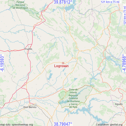
Logrosán GPS coordinates[2]
39° 20' 11.076" North, 5° 29' 34.116" West
| Map corner | latitude | longitude |
|---|---|---|
| Upper-left | 39.87812°, | -6.19593° |
| Center: | 39.33641°, | -5.49281° |
| Lower-right: | 38.79047°, | -4.78968° |
| Map W x H: | 120.9×120.9 km | = 75.1×75.1mi |
| max Lat: | 43.74134° ⇑78.3% North |
| Logrosán: | 39.33641° |
| min Lat: | ⇓21.7% South 27.64134° |
| min Long | Logrosán | max Long |
| -18.00367° | -5.49281° | 4.2899° |
| W 21.4%⇐ | ⇒78.6% E |
Elevation
Elevation of Logrosán is 473 m = 1552 ft, and this is 125 m = 410 ft below average elevation for this country.
| Max E: |
1682 m = 5518 ft | 64% |
| Avg. | 598 m = 1962 ft | |
| Logrosán | 473 m = 1552 ft | |
Min E: |
0 m = 0 ft | 36% |
See also: Spain elevation on elevation.city.
Geographical zone
Logrosán is located in North temperate zone (between Tropic of Cancer and the Arctic Circle). Distance of this Northern Tropic circle is 1767.9 km =1098.5 mi to South.| Distance of | km | miles | from Logrosán |
|---|---|---|---|
| North Pole | 5633.3 | 3500.4 | to North |
| Arctic Circle | 3027.4 | 1881.1 | to North |
| Tropic Cancer | 1767.9 | 1098.5 | to South |
| Equator | 4373.8 | 2717.8 | to South |


Nearby cities:
15 places around Logrosán: (largest is in red/bold)
• Alcollarín
23.5 km =14.6 mi,  244°
244°
• Aldeacentenera
24.2 km =15 mi,  331°
331°
• Alía
26.7 km =16.6 mi,  62°
62°
• Berzocana
11.5 km =7.1 mi,  13°
13°
• Cabañas del Castillo
23.6 km =14.7 mi,  355°
355°
• Cañamero
10.2 km =6.3 mi, 61°
• Conquista de la Sierra
20.9 km =13 mi,  274°
274°
• Garcíaz
14.4 km =8.9 mi,  306°
306°
• Guadalupe
19.2 km =11.9 mi,  48°
48°
• Herguijuela
23.4 km =14.5 mi,  280°
280°
• Madrigalejo
24.9 km =15.5 mi,  207°
207°
• Madroñera
24.7 km =15.3 mi,  293°
293°
• Navalvillar de Pela
27 km =16.8 mi,  175°
175°
• Navezuelas
19.8 km =12.3 mi, 13°
• Zorita
18.7 km =11.6 mi,  252°
252°
Sources, notices
• [Note1] Compared only with cities in Spain existing in our database
• [Src1] Map data: © OpenStreetMap contributors (CC-BY-SA)
• [Src2] Other city data from geonames.org with taken over terms of usage.
• [Src3] Geographical zone / Annual Mean Temperature by Robert A. Rohde @ Wikipedia
