Abertura geodata
Abertura (Extremadura) is a seat of a third-order administrative division; located in Spain in Europe/Madrid (GMT+2) time zone. With population of 509 people, there are 3858 cities with bigger population in this country. Compared to other cities in Spain, 79.1% of cities are located further ↑North; 83.5% of cities are located further →East and 68.9% of cities have higher elevation than Abertura. Note1


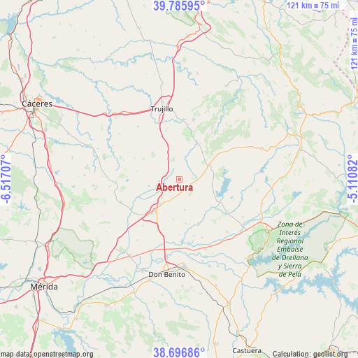
Abertura GPS coordinates[2]
39° 14' 36.672" North, 5° 48' 50.184" West
| Map corner | latitude | longitude |
|---|---|---|
| Upper-left | 39.78595°, | -6.51707° |
| Center: | 39.24352°, | -5.81394° |
| Lower-right: | 38.69686°, | -5.11082° |
| Map W x H: | 121.1×121.1 km | = 75.2×75.2mi |
| max Lat: | 43.74134° ⇑79.1% North |
| Abertura: | 39.24352° |
| min Lat: | ⇓20.9% South 27.64134° |
| min Long | Abertura | max Long |
| -18.00367° | -5.81394° | 4.2899° |
| W 16.5%⇐ | ⇒83.5% E |
Elevation
Elevation of Abertura is 400 m = 1312 ft, and this is 198 m = 650 ft below average elevation for this country.
| Max E: |
1682 m = 5518 ft | 68.9% |
| Avg. | 598 m = 1962 ft | |
| Abertura | 400 m = 1312 ft | |
Min E: |
0 m = 0 ft | 31.1% |
See also: Spain elevation on elevation.city.
Geographical zone
Abertura is located in North temperate zone (between Tropic of Cancer and the Arctic Circle). Distance of this Northern Tropic circle is 1757.6 km =1092.1 mi to South.| Distance of | km | miles | from Abertura |
|---|---|---|---|
| North Pole | 5643.6 | 3506.8 | to North |
| Arctic Circle | 3037.7 | 1887.5 | to North |
| Tropic Cancer | 1757.6 | 1092.1 | to South |
| Equator | 4363.5 | 2711.4 | to South |


Nearby cities:
15 places around Abertura: (largest is in red/bold)
• Alcollarín
6.4 km =4 mi,  88°
88°
• Conquista de la Sierra
13.7 km =8.5 mi,  29°
29°
• Escurial
10.3 km =6.4 mi,  216°
216°
• Herguijuela
15.3 km =9.5 mi,  17°
17°
• Ibahernando
12.8 km =8 mi,  315°
315°
• Miajadas
13.1 km =8.1 mi, 218°
• Puerto de Santa Cruz
9 km =5.6 mi,  334°
334°
• Robledillo de Trujillo
14.6 km =9.1 mi,  281°
281°
• Ruanes
19.6 km =12.2 mi,  298°
298°
• Santa Ana
16.8 km =10.4 mi, 295°
• Santa Cruz de la Sierra
10.7 km =6.6 mi,  345°
345°
• Villamesías
5.1 km =3.2 mi,  272°
272°
• Villar de Rena
18.6 km =11.6 mi,  179°
179°
• Zarza de Montánchez
18.9 km =11.7 mi, 274°
• Zorita
10.9 km =6.8 mi,  64°
64°
Sources, notices
• [Note1] Compared only with cities in Spain existing in our database
• [Src1] Map data: © OpenStreetMap contributors (CC-BY-SA)
• [Src2] Other city data from geonames.org with taken over terms of usage.
• [Src3] Geographical zone / Annual Mean Temperature by Robert A. Rohde @ Wikipedia
