Madrigalejo geodata
Madrigalejo (Extremadura) is a seat of a third-order administrative division; located in Spain in Europe/Madrid (GMT+2) time zone. With population of 2,093 people, there are 2103 cities with bigger population in this country. Compared to other cities in Spain, 79.9% of cities are located further ↑North; 80.5% of cities are located further →East and 75% of cities have higher elevation than Madrigalejo. Note1


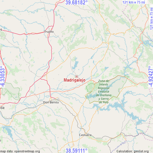
Madrigalejo GPS coordinates[2]
39° 8' 18.888" North, 5° 37' 38.64" West
| Map corner | latitude | longitude |
|---|---|---|
| Upper-left | 39.68182°, | -6.33053° |
| Center: | 39.13858°, | -5.6274° |
| Lower-right: | 38.59111°, | -4.92427° |
| Map W x H: | 121.3×121.3 km | = 75.4×75.4mi |
| max Lat: | 43.74134° ⇑79.9% North |
| Madrigalejo: | 39.13858° |
| min Lat: | ⇓20.1% South 27.64134° |
| min Long | Madrigalejo | max Long |
| -18.00367° | -5.6274° | 4.2899° |
| W 19.5%⇐ | ⇒80.5% E |
Elevation
Elevation of Madrigalejo is 297 m = 974 ft, and this is 301 m = 988 ft below average elevation for this country.
| Max E: |
1682 m = 5518 ft | 75% |
| Avg. | 598 m = 1962 ft | |
| Madrigalejo | 297 m = 974 ft | |
Min E: |
0 m = 0 ft | 25% |
See also: Spain elevation on elevation.city.
Geographical zone
Madrigalejo is located in North temperate zone (between Tropic of Cancer and the Arctic Circle). Distance of this Northern Tropic circle is 1745.9 km =1084.9 mi to South.| Distance of | km | miles | from Madrigalejo |
|---|---|---|---|
| North Pole | 5655.3 | 3514 | to North |
| Arctic Circle | 3049.4 | 1894.8 | to North |
| Tropic Cancer | 1745.9 | 1084.9 | to South |
| Equator | 4351.8 | 2704.1 | to South |


Nearby cities:
15 places around Madrigalejo: (largest is in red/bold)
• Abertura
19.9 km =12.4 mi,  305°
305°
• Acedera
8.3 km =5.2 mi,  146°
146°
• Alcollarín
15.2 km =9.4 mi,  320°
320°
• Conquista de la Sierra
25.3 km =15.7 mi,  338°
338°
• Escurial
22.4 km =13.9 mi,  278°
278°
• La Coronada
24.5 km =15.2 mi,  188°
188°
• Logrosán
24.9 km =15.5 mi,  27°
27°
• Miajadas
24.3 km =15.1 mi,  273°
273°
• Navalvillar de Pela
14.6 km =9.1 mi,  109°
109°
• Orellana la Vieja
16.8 km =10.4 mi, 151°
• Rena
18.3 km =11.4 mi,  238°
238°
• Villamesías
24.3 km =15.1 mi,  299°
299°
• Villanueva de la Serena
23.2 km =14.4 mi,  219°
219°
• Villar de Rena
17.3 km =10.7 mi,  246°
246°
• Zorita
17.5 km =10.9 mi, 339°
Sources, notices
• [Note1] Compared only with cities in Spain existing in our database
• [Src1] Map data: © OpenStreetMap contributors (CC-BY-SA)
• [Src2] Other city data from geonames.org with taken over terms of usage.
• [Src3] Geographical zone / Annual Mean Temperature by Robert A. Rohde @ Wikipedia
