Zahinos geodata
Zahinos (Extremadura) is a populated place; located in Spain in Europe/Madrid (GMT+2) time zone. With population of 2,934 people, there are 1744 cities with bigger population in this country. Compared to other cities in Spain, 86.6% of cities are located further ↑North; 94.1% of cities are located further →East and 73.1% of cities have higher elevation than Zahinos. Note1


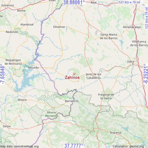
Zahinos GPS coordinates[2]
38° 19' 52.86" North, 6° 57' 19.188" West
| Map corner | latitude | longitude |
|---|---|---|
| Upper-left | 38.88081°, | -7.65846° |
| Center: | 38.33135°, | -6.95533° |
| Lower-right: | 37.7777°, | -6.25221° |
| Map W x H: | 122.7×122.7 km | = 76.2×76.2mi |
| max Lat: | 43.74134° ⇑86.6% North |
| Zahinos: | 38.33135° |
| min Lat: | ⇓13.4% South 27.64134° |
| min Long | Zahinos | max Long |
| -18.00367° | -6.95533° | 4.2899° |
| W 5.9%⇐ | ⇒94.1% E |
Elevation
Elevation of Zahinos is 330 m = 1083 ft, and this is 268 m = 879 ft below average elevation for this country.
| Max E: |
1682 m = 5518 ft | 73.1% |
| Avg. | 598 m = 1962 ft | |
| Zahinos | 330 m = 1083 ft | |
Min E: |
0 m = 0 ft | 26.9% |
See also: Spain elevation on elevation.city.
Geographical zone
Zahinos is located in North temperate zone (between Tropic of Cancer and the Arctic Circle). Distance of this Northern Tropic circle is 1656.1 km =1029.1 mi to South.| Distance of | km | miles | from Zahinos |
|---|---|---|---|
| North Pole | 5745 | 3569.8 | to North |
| Arctic Circle | 3139.1 | 1950.5 | to North |
| Tropic Cancer | 1656.1 | 1029.1 | to South |
| Equator | 4262 | 2648.3 | to South |


Nearby cities:
15 places around Zahinos: (largest is in red/bold)
• Alconchel
22.9 km =14.2 mi,  333°
333°
• Barcarrota
22.4 km =13.9 mi,  24°
24°
• Encinasola
23.3 km =14.5 mi,  160°
160°
• Fregenal de la Sierra
31.9 km =19.8 mi,  124°
124°
• Higuera de Vargas
13 km =8.1 mi,  352°
352°
• Higuera la Real
31.4 km =19.5 mi,  132°
132°
• Jerez de los Caballeros
16 km =9.9 mi,  94°
94°
• Oliva de la Frontera
6.9 km =4.3 mi,  152°
152°
• Salvaleón
24.7 km =15.3 mi,  36°
36°
• Salvatierra de los Barros
29.5 km =18.3 mi,  53°
53°
• Táliga
22.6 km =14 mi, 346°
• Valencia del Mombuey
17.4 km =10.8 mi,  235°
235°
• Valle de Matamoros
14.2 km =8.8 mi,  68°
68°
• Valle de Santa Ana
15.1 km =9.4 mi,  75°
75°
• Villanueva del Fresno
19.2 km =11.9 mi,  285°
285°
Sources, notices
• [Note1] Compared only with cities in Spain existing in our database
• [Src1] Map data: © OpenStreetMap contributors (CC-BY-SA)
• [Src2] Other city data from geonames.org with taken over terms of usage.
• [Src3] Geographical zone / Annual Mean Temperature by Robert A. Rohde @ Wikipedia
