Encinasola geodata
Encinasola (Andalusia) is a seat of a third-order administrative division; located in Spain in Europe/Madrid (GMT+2) time zone. In our database, there are 6762 cities with bigger population. Compared to other cities in Spain, 87.6% of cities are located further ↑North; 93.8% of cities are located further →East and 67.3% of cities have higher elevation than Encinasola. Note1


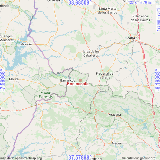
Encinasola GPS coordinates[2]
38° 8' 2.868" North, 6° 52' 0.3" West
| Map corner | latitude | longitude |
|---|---|---|
| Upper-left | 38.68509°, | -7.56988° |
| Center: | 38.13413°, | -6.86675° |
| Lower-right: | 37.57898°, | -6.16363° |
| Map W x H: | 123×123 km | = 76.4×76.4mi |
| max Lat: | 43.74134° ⇑87.6% North |
| Encinasola: | 38.13413° |
| min Lat: | ⇓12.4% South 27.64134° |
| min Long | Encinasola | max Long |
| -18.00367° | -6.86675° | 4.2899° |
| W 6.2%⇐ | ⇒93.8% E |
Elevation
Elevation of Encinasola is 428 m = 1404 ft, and this is 170 m = 558 ft below average elevation for this country.
| Max E: |
1682 m = 5518 ft | 67.3% |
| Avg. | 598 m = 1962 ft | |
| Encinasola | 428 m = 1404 ft | |
Min E: |
0 m = 0 ft | 32.7% |
See also: Spain elevation on elevation.city.
Geographical zone
Encinasola is located in North temperate zone (between Tropic of Cancer and the Arctic Circle). Distance of this Northern Tropic circle is 1634.2 km =1015.4 mi to South.| Distance of | km | miles | from Encinasola |
|---|---|---|---|
| North Pole | 5766.9 | 3583.4 | to North |
| Arctic Circle | 3161.1 | 1964.2 | to North |
| Tropic Cancer | 1634.2 | 1015.4 | to South |
| Equator | 4240.1 | 2634.7 | to South |


Nearby cities:
15 places around Encinasola: (largest is in red/bold)
• Aroche
22.8 km =14.2 mi,  200°
200°
• Bodonal de la Sierra
26.9 km =16.7 mi,  86°
86°
• Cortegana
25.1 km =15.6 mi,  170°
170°
• Cumbres Mayores
20.9 km =13 mi,  112°
112°
• Fregenal de la Sierra
19 km =11.8 mi,  78°
78°
• Galaroza
26.8 km =16.7 mi,  148°
148°
• Higuera la Real
15.5 km =9.6 mi, 87°
• Jabugo
27 km =16.8 mi, 153°
• Jerez de los Caballeros
22.3 km =13.9 mi,  21°
21°
• Oliva de la Frontera
16.4 km =10.2 mi,  343°
343°
• Valdelarco
26.2 km =16.3 mi,  141°
141°
• Valencia del Mombuey
25.2 km =15.7 mi,  298°
298°
• Valle de Matamoros
27.8 km =17.3 mi,  11°
11°
• Valle de Santa Ana
26.7 km =16.6 mi, 14°
• Zahinos
23.3 km =14.5 mi, 340°
Sources, notices
• [Note1] Compared only with cities in Spain existing in our database
• [Src1] Map data: © OpenStreetMap contributors (CC-BY-SA)
• [Src2] Other city data from geonames.org with taken over terms of usage.
• [Src3] Geographical zone / Annual Mean Temperature by Robert A. Rohde @ Wikipedia
