Barcarrota geodata
Barcarrota (Extremadura) is a seat of a third-order administrative division; located in Spain in Europe/Madrid (GMT+2) time zone. With population of 3,643 people, there are 1554 cities with bigger population in this country. Compared to other cities in Spain, 85.6% of cities are located further ↑North; 93.7% of cities are located further →East and 62.8% of cities have higher elevation than Barcarrota. Note1


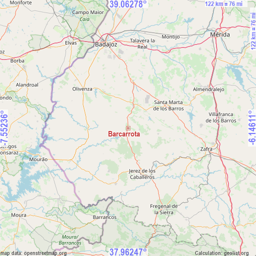
Barcarrota GPS coordinates[2]
38° 30' 53.028" North, 6° 50' 57.228" West
| Map corner | latitude | longitude |
|---|---|---|
| Upper-left | 39.06278°, | -7.55236° |
| Center: | 38.51473°, | -6.84923° |
| Lower-right: | 37.96247°, | -6.14611° |
| Map W x H: | 122.3×122.3 km | = 76×76mi |
| max Lat: | 43.74134° ⇑85.6% North |
| Barcarrota: | 38.51473° |
| min Lat: | ⇓14.4% South 27.64134° |
| min Long | Barcarrota | max Long |
| -18.00367° | -6.84923° | 4.2899° |
| W 6.3%⇐ | ⇒93.7% E |
Elevation
Elevation of Barcarrota is 489 m = 1604 ft, and this is 109 m = 358 ft below average elevation for this country.
| Max E: |
1682 m = 5518 ft | 62.8% |
| Avg. | 598 m = 1962 ft | |
| Barcarrota | 489 m = 1604 ft | |
Min E: |
0 m = 0 ft | 37.2% |
See also: Spain elevation on elevation.city.
Geographical zone
Barcarrota is located in North temperate zone (between Tropic of Cancer and the Arctic Circle). Distance of this Northern Tropic circle is 1676.5 km =1041.7 mi to South.| Distance of | km | miles | from Barcarrota |
|---|---|---|---|
| North Pole | 5724.6 | 3557.1 | to North |
| Arctic Circle | 3118.7 | 1937.9 | to North |
| Tropic Cancer | 1676.5 | 1041.7 | to South |
| Equator | 4282.4 | 2661 | to South |


Nearby cities:
15 places around Barcarrota: (largest is in red/bold)
• Alconchel
19.3 km =12 mi,  270°
270°
• Almendral
11.3 km =7 mi,  12°
12°
• Higuera de Vargas
13.3 km =8.3 mi,  235°
235°
• La Morera
17.4 km =10.8 mi,  78°
78°
• La Parra
19.7 km =12.2 mi,  87°
87°
• Nogales
11.8 km =7.3 mi,  47°
47°
• Salvaleón
5.5 km =3.4 mi,  95°
95°
• Salvatierra de los Barros
14.6 km =9.1 mi, 100°
• Santa Marta
22.2 km =13.8 mi,  60°
60°
• Torre de Miguel Sesmero
12.5 km =7.8 mi,  21°
21°
• Táliga
14.7 km =9.1 mi,  276°
276°
• Valle de Matamoros
15.6 km =9.7 mi,  165°
165°
• Valle de Santa Ana
17.3 km =10.7 mi,  162°
162°
• Valverde de Leganés
20.7 km =12.9 mi,  326°
326°
• Zahinos
22.4 km =13.9 mi,  204°
204°
Sources, notices
• [Note1] Compared only with cities in Spain existing in our database
• [Src1] Map data: © OpenStreetMap contributors (CC-BY-SA)
• [Src2] Other city data from geonames.org with taken over terms of usage.
• [Src3] Geographical zone / Annual Mean Temperature by Robert A. Rohde @ Wikipedia
