Jerez de los Caballeros geodata
Jerez de los Caballeros (Extremadura) is a seat of a third-order administrative division; located in Spain in Europe/Madrid (GMT+2) time zone. With population of 10,237 people, there are 845 cities with bigger population in this country. Compared to other cities in Spain, 86.7% of cities are located further ↑North; 93.3% of cities are located further →East and 63.1% of cities have higher elevation than Jerez de los Caballeros. Note1
Administrative division(s):
- Level 1: Extremadura
- Level 2: Provincia de Badajoz
- Level 3: Jerez de los Caballeros
Current local time in Jerez de los Caballeros:
11:57 PM, ThursdayDifference from your time zone: hours


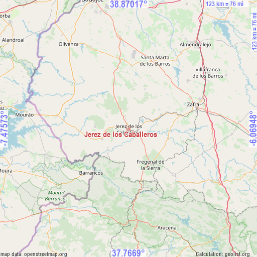
Jerez de los Caballeros GPS coordinates[2]
38° 19' 14.268" North, 6° 46' 21.36" West
| Map corner | latitude | longitude |
|---|---|---|
| Upper-left | 38.87017°, | -7.47573° |
| Center: | 38.32063°, | -6.7726° |
| Lower-right: | 37.7669°, | -6.06948° |
| Map W x H: | 122.7×122.7 km | = 76.2×76.2mi |
| max Lat: | 43.74134° ⇑86.7% North |
| Jerez de los Caballeros: | 38.32063° |
| min Lat: | ⇓13.3% South 27.64134° |
| min Long | Jerez de los Ca | max Long |
| -18.00367° | -6.7726° | 4.2899° |
| W 6.7%⇐ | ⇒93.3% E |
Elevation
Elevation of Jerez de los Caballeros is 486 m = 1594 ft, and this is 112 m = 367 ft below average elevation for this country.
| Max E: |
1682 m = 5518 ft | 63.1% |
| Avg. | 598 m = 1962 ft | |
| Jerez de los Caballeros | 486 m = 1594 ft | |
Min E: |
0 m = 0 ft | 36.9% |
See also: Spain elevation on elevation.city.
Geographical zone
Jerez de los Caballeros is located in North temperate zone (between Tropic of Cancer and the Arctic Circle). Distance of this Northern Tropic circle is 1654.9 km =1028.3 mi to South.| Distance of | km | miles | from Jerez de los Caballeros |
|---|---|---|---|
| North Pole | 5746.2 | 3570.5 | to North |
| Arctic Circle | 3140.3 | 1951.3 | to North |
| Tropic Cancer | 1654.9 | 1028.3 | to South |
| Equator | 4260.9 | 2647.6 | to South |


Nearby cities:
15 places around Jerez de los Caballeros: (largest is in red/bold)
• Atalaya
26.7 km =16.6 mi,  86°
86°
• Barcarrota
22.6 km =14 mi,  342°
342°
• Burguillos del Cerro
17.2 km =10.7 mi,  67°
67°
• Encinasola
22.3 km =13.9 mi,  201°
201°
• Fregenal de la Sierra
19.8 km =12.3 mi,  148°
148°
• Higuera de Vargas
22.6 km =14 mi,  308°
308°
• Higuera la Real
21.3 km =13.2 mi,  159°
159°
• La Parra
25.8 km =16 mi,  30°
30°
• Oliva de la Frontera
13.7 km =8.5 mi,  248°
248°
• Salvaleón
21.1 km =13.1 mi,  356°
356°
• Salvatierra de los Barros
20.4 km =12.7 mi,  22°
22°
• Valle de Matamoros
7 km =4.3 mi, 337°
• Valle de Santa Ana
5.3 km =3.3 mi, 344°
• Valverde de Burguillos
20.6 km =12.8 mi, 87°
• Zahinos
16 km =9.9 mi,  274°
274°
Sources, notices
• [Note1] Compared only with cities in Spain existing in our database
• [Src1] Map data: © OpenStreetMap contributors (CC-BY-SA)
• [Src2] Other city data from geonames.org with taken over terms of usage.
• [Src3] Geographical zone / Annual Mean Temperature by Robert A. Rohde @ Wikipedia
