Yémeda geodata
Yémeda (Castille-La Mancha) is a seat of a third-order administrative division; located in Spain in Europe/Madrid (GMT+2) time zone. With population of 26 people, there are 6687 cities with bigger population in this country. Compared to other cities in Spain, 73.3% of cities are located further ↑North; 70.4% of cities are located further ←West and 82.5% of cities have lower elevation than Yémeda. Note1
Administrative division(s):
- Level 1: Castille-La Mancha
- Level 2: Provincia de Cuenca
- Level 3: Yémeda


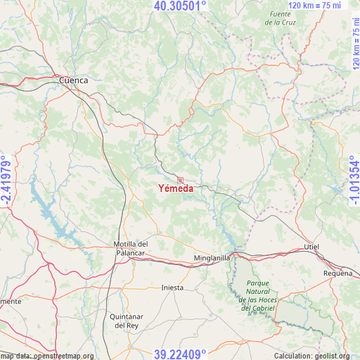
Yémeda GPS coordinates[2]
39° 46' 0.012" North, 1° 43' 0.012" West
| Map corner | latitude | longitude |
|---|---|---|
| Upper-left | 40.30501°, | -2.41979° |
| Center: | 39.76667°, | -1.71667° |
| Lower-right: | 39.22409°, | -1.01354° |
| Map W x H: | 120.2×120.2 km | = 74.7×74.7mi |
| max Lat: | 43.74134° ⇑73.3% North |
| Yémeda: | 39.76667° |
| min Lat: | ⇓26.7% South 27.64134° |
| min Long | Yémeda | max Long |
| -18.00367° | -1.71667° | 4.2899° |
| W 70.4%⇐ | ⇒29.6% E |
Elevation
Elevation of Yémeda is 922 m = 3025 ft, and this is 324 m = 1063 ft above average elevation for this country.
| Max E: |
1682 m = 5518 ft | 17.5% |
| Yémeda | 922 m 3025 ft | |
| Avg. | 598 m = 1962 ft | |
Min E: |
0 m = 0 ft | 82.5% |
See also: Spain elevation on elevation.city.
Geographical zone
Yémeda is located in North temperate zone (between Tropic of Cancer and the Arctic Circle). Distance of this Northern Tropic circle is 1815.7 km =1128.2 mi to South.| Distance of | km | miles | from Yémeda |
|---|---|---|---|
| North Pole | 5585.4 | 3470.6 | to North |
| Arctic Circle | 2979.5 | 1851.4 | to North |
| Tropic Cancer | 1815.7 | 1128.2 | to South |
| Equator | 4421.6 | 2747.5 | to South |


Nearby cities:
15 places around Yémeda: (largest is in red/bold)
• Almodóvar del Pinar
15.3 km =9.5 mi,  248°
248°
• Arguisuelas
11.3 km =7 mi,  310°
310°
• Campillo de Altobuey
19.9 km =12.4 mi,  201°
201°
• Carboneras de Guadazaón
14.8 km =9.2 mi,  331°
331°
• Cardenete
2.8 km =1.7 mi,  90°
90°
• Enguídanos
14.9 km =9.3 mi,  138°
138°
• Monteagudo de las Salinas
16.1 km =10 mi,  283°
283°
• Narboneta
21.4 km =13.3 mi, 94°
• Pajaroncillo
20.4 km =12.7 mi,  356°
356°
• Pajarón
21.2 km =13.2 mi,  344°
344°
• Paracuellos
8 km =5 mi,  225°
225°
• Puebla del Salvador
22.6 km =14 mi,  169°
169°
• Reíllo
19.6 km =12.2 mi,  319°
319°
• San Martín de Boniches
19.6 km =12.2 mi,  40°
40°
• Villar del Humo
13.2 km =8.2 mi,  32°
32°
Sources, notices
• [Note1] Compared only with cities in Spain existing in our database
• [Src1] Map data: © OpenStreetMap contributors (CC-BY-SA)
• [Src2] Other city data from geonames.org with taken over terms of usage.
• [Src3] Geographical zone / Annual Mean Temperature by Robert A. Rohde @ Wikipedia
