Villanueva del Río y Minas geodata
Villanueva del Río y Minas (Andalusia) is a seat of a third-order administrative division; located in Spain in Europe/Madrid (GMT+2) time zone. With population of 5,213 people, there are 1264 cities with bigger population in this country. Compared to other cities in Spain, 90.3% of cities are located further ↑North; 82% of cities are located further →East and 89.9% of cities have higher elevation than Villanueva del Río y Minas. Note1
Administrative division(s):
- Level 1: Andalusia
- Level 2: Provincia de Sevilla
- Level 3: Villanueva del Río y Minas
Current local time in Villanueva del Río y Minas:
09:17 PM, ThursdayDifference from your time zone: hours


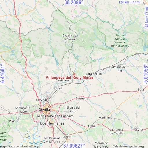
Villanueva del Río y Minas GPS coordinates[2]
37° 39' 18.072" North, 5° 42' 49.284" West
| Map corner | latitude | longitude |
|---|---|---|
| Upper-left | 38.2096°, | -6.41681° |
| Center: | 37.65502°, | -5.71369° |
| Lower-right: | 37.09627°, | -5.01056° |
| Map W x H: | 123.8×123.8 km | = 76.9×76.9mi |
| max Lat: | 43.74134° ⇑90.3% North |
| Villanueva del Río y Minas: | 37.65502° |
| min Lat: | ⇓9.7% South 27.64134° |
| min Long | Villanueva del | max Long |
| -18.00367° | -5.71369° | 4.2899° |
| W 18%⇐ | ⇒82% E |
Elevation
Elevation of Villanueva del Río y Minas is 67 m = 220 ft, and this is 531 m = 1742 ft below average elevation for this country.
| Max E: |
1682 m = 5518 ft | 89.9% |
| Avg. | 598 m = 1962 ft | |
| Villanueva del Río y Minas | 67 m = 220 ft | |
Min E: |
0 m = 0 ft | 10.1% |
See also: Spain elevation on elevation.city.
Geographical zone
Villanueva del Río y Minas is located in North temperate zone (between Tropic of Cancer and the Arctic Circle). Distance of this Northern Tropic circle is 1580.9 km =982.3 mi to South.| Distance of | km | miles | from Villanueva del Río y Minas |
|---|---|---|---|
| North Pole | 5820.2 | 3616.5 | to North |
| Arctic Circle | 3214.3 | 1997.3 | to North |
| Tropic Cancer | 1580.9 | 982.3 | to South |
| Equator | 4186.8 | 2601.6 | to South |


Nearby cities:
15 places around Villanueva del Río y Minas: (largest is in red/bold)
• Alcalá del Río
28.1 km =17.5 mi,  237°
237°
• Alcolea del Río
6.1 km =3.8 mi,  137°
137°
• Brenes
18.2 km =11.3 mi,  229°
229°
• Burguillos
23.6 km =14.7 mi,  250°
250°
• Cantillana
11 km =6.8 mi, 243°
• Carmona
21.3 km =13.2 mi,  163°
163°
• Castilblanco de los Arroyos
24.3 km =15.1 mi,  275°
275°
• Cazalla de la Sierra
31.1 km =19.3 mi,  354°
354°
• Constantina
25 km =15.5 mi,  19°
19°
• El Viso del Alcor
29.4 km =18.3 mi,  181°
181°
• La Campana
27 km =16.8 mi,  110°
110°
• La Rinconada
30.1 km =18.7 mi, 231°
• Lora del Río
16.4 km =10.2 mi,  88°
88°
• Tocina
5.4 km =3.4 mi,  199°
199°
• Villaverde del Río
15.9 km =9.9 mi, 242°
Sources, notices
• [Note1] Compared only with cities in Spain existing in our database
• [Src1] Map data: © OpenStreetMap contributors (CC-BY-SA)
• [Src2] Other city data from geonames.org with taken over terms of usage.
• [Src3] Geographical zone / Annual Mean Temperature by Robert A. Rohde @ Wikipedia
