Carmona geodata
Carmona (Andalusia) is a seat of a third-order administrative division; located in Spain in Europe/Madrid (GMT+2) time zone. With population of 28,344 people, there are 329 cities with bigger population in this country. Compared to other cities in Spain, 91.5% of cities are located further ↑North; 80.8% of cities are located further →East and 79.9% of cities have higher elevation than Carmona. Note1


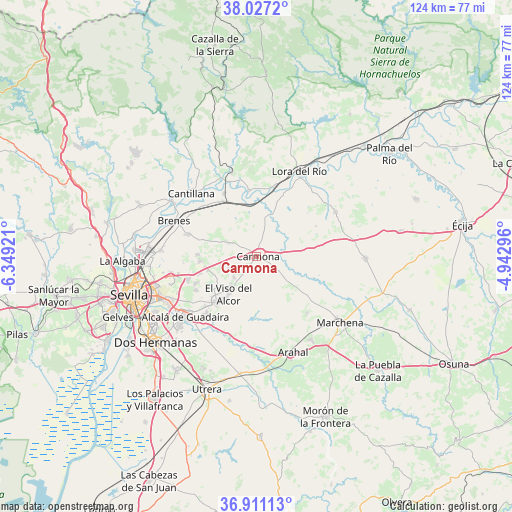
Carmona GPS coordinates[2]
37° 28' 16.5" North, 5° 38' 45.888" West
| Map corner | latitude | longitude |
|---|---|---|
| Upper-left | 38.0272°, | -6.34921° |
| Center: | 37.47125°, | -5.64608° |
| Lower-right: | 36.91113°, | -4.94296° |
| Map W x H: | 124.1×124.1 km | = 77.1×77.1mi |
| max Lat: | 43.74134° ⇑91.5% North |
| Carmona: | 37.47125° |
| min Lat: | ⇓8.5% South 27.64134° |
| min Long | Carmona | max Long |
| -18.00367° | -5.64608° | 4.2899° |
| W 19.2%⇐ | ⇒80.8% E |
Elevation
Elevation of Carmona is 221 m = 725 ft, and this is 377 m = 1237 ft below average elevation for this country.
| Max E: |
1682 m = 5518 ft | 79.9% |
| Avg. | 598 m = 1962 ft | |
| Carmona | 221 m = 725 ft | |
Min E: |
0 m = 0 ft | 20.1% |
See also: Spain elevation on elevation.city.
Geographical zone
Carmona is located in North temperate zone (between Tropic of Cancer and the Arctic Circle). Distance of this Northern Tropic circle is 1560.5 km =969.6 mi to South.| Distance of | km | miles | from Carmona |
|---|---|---|---|
| North Pole | 5840.6 | 3629.2 | to North |
| Arctic Circle | 3234.8 | 2010 | to North |
| Tropic Cancer | 1560.5 | 969.6 | to South |
| Equator | 4166.4 | 2588.9 | to South |


Nearby cities:
15 places around Carmona: (largest is in red/bold)
• Alcalá de Guadaira
22.6 km =14 mi,  229°
229°
• Alcolea del Río
16.1 km =10 mi,  353°
353°
• Brenes
21.7 km =13.5 mi,  293°
293°
• Cantillana
22.1 km =13.7 mi,  314°
314°
• El Arahal
24.8 km =15.4 mi,  158°
158°
• El Viso del Alcor
11 km =6.8 mi,  216°
216°
• La Campana
22.2 km =13.8 mi,  60°
60°
• Lora del Río
23.3 km =14.5 mi,  26°
26°
• Mairena del Alcor
14.2 km =8.8 mi, 219°
• Marchena
25.7 km =16 mi,  127°
127°
• Paradas
24 km =14.9 mi,  146°
146°
• Tocina
17.2 km =10.7 mi,  333°
333°
• Valdezorras
25.2 km =15.7 mi,  259°
259°
• Villanueva del Río y Minas
21.3 km =13.2 mi,  343°
343°
• Villaverde del Río
24 km =14.9 mi,  303°
303°
Sources, notices
• [Note1] Compared only with cities in Spain existing in our database
• [Src1] Map data: © OpenStreetMap contributors (CC-BY-SA)
• [Src2] Other city data from geonames.org with taken over terms of usage.
• [Src3] Geographical zone / Annual Mean Temperature by Robert A. Rohde @ Wikipedia
