El Viso del Alcor geodata
El Viso del Alcor (Andalusia) is a populated place; located in Spain in Europe/Madrid (GMT+2) time zone. With population of 18,351 people, there are 509 cities with bigger population in this country. Compared to other cities in Spain, 92% of cities are located further ↑North; 82% of cities are located further →East and 83.1% of cities have higher elevation than El Viso del Alcor. Note1
Administrative division(s):
- Level 1: Andalusia
- Level 2: Provincia de Sevilla
- Level 3: Viso del Alcor, El


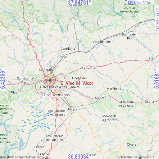
El Viso del Alcor GPS coordinates[2]
37° 23' 27.816" North, 5° 43' 11.748" West
| Map corner | latitude | longitude |
|---|---|---|
| Upper-left | 37.94761°, | -6.42306° |
| Center: | 37.39106°, | -5.71993° |
| Lower-right: | 36.83034°, | -5.01681° |
| Map W x H: | 124.2×124.2 km | = 77.2×77.2mi |
| max Lat: | 43.74134° ⇑92% North |
| El Viso del Alcor: | 37.39106° |
| min Lat: | ⇓8% South 27.64134° |
| min Long | El Viso del Alc | max Long |
| -18.00367° | -5.71993° | 4.2899° |
| W 18%⇐ | ⇒82% E |
Elevation
Elevation of El Viso del Alcor is 167 m = 548 ft, and this is 431 m = 1414 ft below average elevation for this country.
| Max E: |
1682 m = 5518 ft | 83.1% |
| Avg. | 598 m = 1962 ft | |
| El Viso del Alcor | 167 m = 548 ft | |
Min E: |
0 m = 0 ft | 16.9% |
See also: Spain elevation on elevation.city.
Geographical zone
El Viso del Alcor is located in North temperate zone (between Tropic of Cancer and the Arctic Circle). Distance of this Northern Tropic circle is 1551.6 km =964.1 mi to South.| Distance of | km | miles | from El Viso del Alcor |
|---|---|---|---|
| North Pole | 5849.6 | 3634.8 | to North |
| Arctic Circle | 3243.7 | 2015.5 | to North |
| Tropic Cancer | 1551.6 | 964.1 | to South |
| Equator | 4157.5 | 2583.3 | to South |


Nearby cities:
15 places around El Viso del Alcor: (largest is in red/bold)
• Alcalá de Guadaira
12.1 km =7.5 mi,  240°
240°
• Alcolea del Río
25.3 km =15.7 mi,  10°
10°
• Brenes
22.1 km =13.7 mi,  322°
322°
• Carmona
11 km =6.8 mi,  36°
36°
• Dos Hermanas
21.5 km =13.4 mi, 235°
• El Arahal
21 km =13 mi,  132°
132°
• La Rinconada
25.3 km =15.7 mi,  294°
294°
• Los Molares
26 km =16.2 mi,  179°
179°
• Mairena del Alcor
3.3 km =2.1 mi,  232°
232°
• Paradas
22.7 km =14.1 mi,  119°
119°
• Sevilla
22.4 km =13.9 mi,  267°
267°
• Tocina
24.3 km =15.1 mi,  357°
357°
• Utrera
23.5 km =14.6 mi,  193°
193°
• Valdezorras
18.7 km =11.6 mi,  283°
283°
• Villaverde del Río
25.9 km =16.1 mi,  328°
328°
Sources, notices
• [Note1] Compared only with cities in Spain existing in our database
• [Src1] Map data: © OpenStreetMap contributors (CC-BY-SA)
• [Src2] Other city data from geonames.org with taken over terms of usage.
• [Src3] Geographical zone / Annual Mean Temperature by Robert A. Rohde @ Wikipedia
