Burguillos geodata
Burguillos (Andalusia) is a seat of a third-order administrative division; located in Spain in Europe/Madrid (GMT+2) time zone. With population of 4,116 people, there are 1449 cities with bigger population in this country. Compared to other cities in Spain, 90.9% of cities are located further ↑North; 85.5% of cities are located further →East and 89.3% of cities have higher elevation than Burguillos. Note1


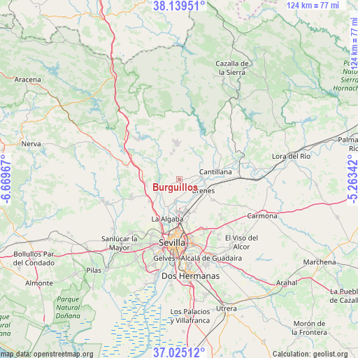
Burguillos GPS coordinates[2]
37° 35' 3.84" North, 5° 57' 59.544" West
| Map corner | latitude | longitude |
|---|---|---|
| Upper-left | 38.13951°, | -6.66967° |
| Center: | 37.5844°, | -5.96654° |
| Lower-right: | 37.02512°, | -5.26342° |
| Map W x H: | 123.9×123.9 km | = 77×77mi |
| max Lat: | 43.74134° ⇑90.9% North |
| Burguillos: | 37.5844° |
| min Lat: | ⇓9.1% South 27.64134° |
| min Long | Burguillos | max Long |
| -18.00367° | -5.96654° | 4.2899° |
| W 14.5%⇐ | ⇒85.5% E |
Elevation
Elevation of Burguillos is 76 m = 249 ft, and this is 522 m = 1713 ft below average elevation for this country.
| Max E: |
1682 m = 5518 ft | 89.3% |
| Avg. | 598 m = 1962 ft | |
| Burguillos | 76 m = 249 ft | |
Min E: |
0 m = 0 ft | 10.7% |
See also: Spain elevation on elevation.city.
Geographical zone
Burguillos is located in North temperate zone (between Tropic of Cancer and the Arctic Circle). Distance of this Northern Tropic circle is 1573.1 km =977.5 mi to South.| Distance of | km | miles | from Burguillos |
|---|---|---|---|
| North Pole | 5828.1 | 3621.4 | to North |
| Arctic Circle | 3222.2 | 2002.2 | to North |
| Tropic Cancer | 1573.1 | 977.5 | to South |
| Equator | 4179 | 2596.7 | to South |


Nearby cities:
15 places around Burguillos: (largest is in red/bold)
• Alcalá del Río
7.5 km =4.7 mi,  190°
190°
• Brenes
9.2 km =5.7 mi,  114°
114°
• Cantillana
12.8 km =8 mi,  77°
77°
• Castilblanco de los Arroyos
10.3 km =6.4 mi,  349°
349°
• Castilleja de Guzmán
21 km =13 mi,  201°
201°
• El Garrobo
18.7 km =11.6 mi,  284°
284°
• Gerena
17.7 km =11 mi,  249°
249°
• Guillena
9.2 km =5.7 mi,  239°
239°
• La Algaba
14 km =8.7 mi, 196°
• La Rinconada
11 km =6.8 mi, 186°
• Santiponce
17.8 km =11.1 mi, 201°
• Tocina
20.7 km =12.9 mi, 82°
• Valdezorras
17.6 km =10.9 mi,  168°
168°
• Valencina de la Concepción
21 km =13 mi,  206°
206°
• Villaverde del Río
8.1 km =5 mi,  86°
86°
Sources, notices
• [Note1] Compared only with cities in Spain existing in our database
• [Src1] Map data: © OpenStreetMap contributors (CC-BY-SA)
• [Src2] Other city data from geonames.org with taken over terms of usage.
• [Src3] Geographical zone / Annual Mean Temperature by Robert A. Rohde @ Wikipedia
