Constantina geodata
Constantina (Andalusia) is a seat of a third-order administrative division; located in Spain in Europe/Madrid (GMT+2) time zone. With population of 6,757 people, there are 1060 cities with bigger population in this country. Compared to other cities in Spain, 89.3% of cities are located further ↑North; 80.4% of cities are located further →East and 59.3% of cities have higher elevation than Constantina. Note1


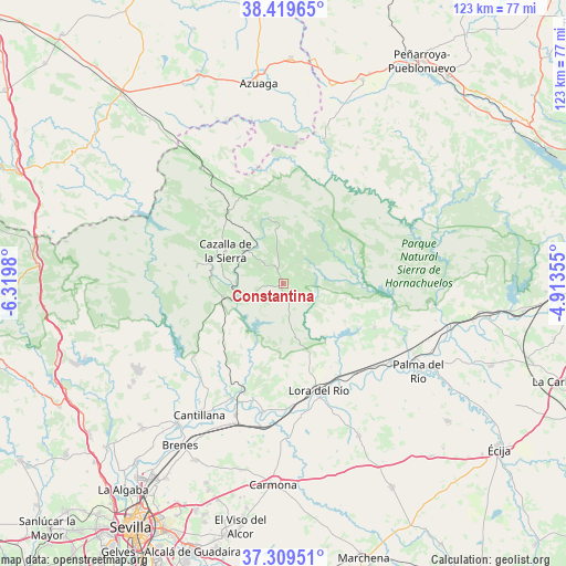
Constantina GPS coordinates[2]
37° 52' 0.012" North, 5° 37' 0.012" West
| Map corner | latitude | longitude |
|---|---|---|
| Upper-left | 38.41965°, | -6.3198° |
| Center: | 37.86667°, | -5.61667° |
| Lower-right: | 37.30951°, | -4.91355° |
| Map W x H: | 123.4×123.4 km | = 76.7×76.7mi |
| max Lat: | 43.74134° ⇑89.3% North |
| Constantina: | 37.86667° |
| min Lat: | ⇓10.7% South 27.64134° |
| min Long | Constantina | max Long |
| -18.00367° | -5.61667° | 4.2899° |
| W 19.6%⇐ | ⇒80.4% E |
Elevation
Elevation of Constantina is 537 m = 1762 ft, and this is 61 m = 200 ft below average elevation for this country.
| Max E: |
1682 m = 5518 ft | 59.3% |
| Avg. | 598 m = 1962 ft | |
| Constantina | 537 m = 1762 ft | |
Min E: |
0 m = 0 ft | 40.7% |
See also: Spain elevation on elevation.city.
Geographical zone
Constantina is located in North temperate zone (between Tropic of Cancer and the Arctic Circle). Distance of this Northern Tropic circle is 1604.5 km =997 mi to South.| Distance of | km | miles | from Constantina |
|---|---|---|---|
| North Pole | 5796.7 | 3601.9 | to North |
| Arctic Circle | 3190.8 | 1982.7 | to North |
| Tropic Cancer | 1604.5 | 997 | to South |
| Equator | 4210.4 | 2616.2 | to South |


Nearby cities:
15 places around Constantina: (largest is in red/bold)
• Alanís
20.5 km =12.7 mi,  334°
334°
• Alcolea del Río
28.3 km =17.6 mi,  188°
188°
• Cantillana
33.9 km =21.1 mi,  212°
212°
• Cazalla de la Sierra
13.8 km =8.6 mi,  302°
302°
• Guadalcanal
31.3 km =19.4 mi, 325°
• Hornachuelos
33.9 km =21.1 mi,  96°
96°
• La Campana
37.1 km =23.1 mi,  153°
153°
• La Puebla de los Infantes
22.2 km =13.8 mi,  115°
115°
• Lora del Río
24.4 km =15.2 mi,  161°
161°
• Malcocinado
28.4 km =17.6 mi,  348°
348°
• Palma del Río
34.8 km =21.6 mi, 122°
• Peñaflor
29.6 km =18.4 mi,  126°
126°
• San Nicolás del Puerto
15.1 km =9.4 mi, 348°
• Tocina
30.4 km =18.9 mi,  199°
199°
• Villanueva del Río y Minas
25 km =15.5 mi, 199°
Sources, notices
• [Note1] Compared only with cities in Spain existing in our database
• [Src1] Map data: © OpenStreetMap contributors (CC-BY-SA)
• [Src2] Other city data from geonames.org with taken over terms of usage.
• [Src3] Geographical zone / Annual Mean Temperature by Robert A. Rohde @ Wikipedia
