Lújar geodata
Lújar (Andalusia) is a seat of a third-order administrative division; located in Spain in Europe/Madrid (GMT+2) time zone. With population of 500 people, there are 3886 cities with bigger population in this country. Compared to other cities in Spain, 96.9% of cities are located further ↑North; 50.8% of cities are located further →East and 57.1% of cities have higher elevation than Lújar. Note1


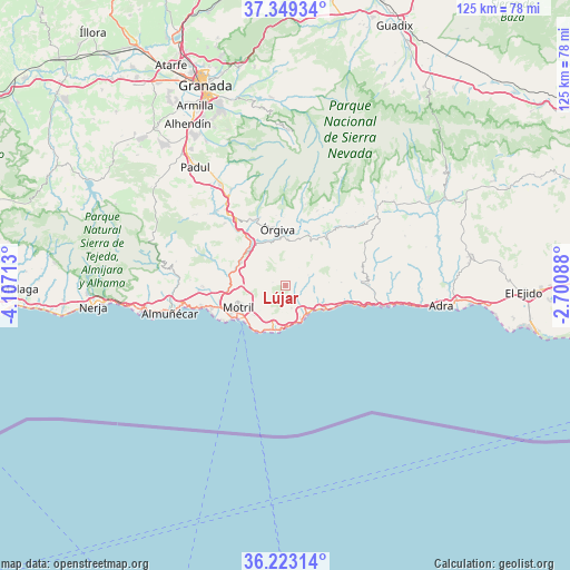
Lújar GPS coordinates[2]
36° 47' 17.916" North, 3° 24' 14.4" West
| Map corner | latitude | longitude |
|---|---|---|
| Upper-left | 37.34934°, | -4.10713° |
| Center: | 36.78831°, | -3.404° |
| Lower-right: | 36.22314°, | -2.70088° |
| Map W x H: | 125.2×125.2 km | = 77.8×77.8mi |
| max Lat: | 43.74134° ⇑96.9% North |
| Lújar: | 36.78831° |
| min Lat: | ⇓3.1% South 27.64134° |
| min Long | Lújar | max Long |
| -18.00367° | -3.404° | 4.2899° |
| W 49.2%⇐ | ⇒50.8% E |
Elevation
Elevation of Lújar is 564 m = 1850 ft, and this is 34 m = 112 ft below average elevation for this country.
| Max E: |
1682 m = 5518 ft | 57.1% |
| Avg. | 598 m = 1962 ft | |
| Lújar | 564 m = 1850 ft | |
Min E: |
0 m = 0 ft | 42.9% |
See also: Spain elevation on elevation.city.
Geographical zone
Lújar is located in North temperate zone (between Tropic of Cancer and the Arctic Circle). Distance of this Northern Tropic circle is 1484.6 km =922.5 mi to South.| Distance of | km | miles | from Lújar |
|---|---|---|---|
| North Pole | 5916.6 | 3676.4 | to North |
| Arctic Circle | 3310.7 | 2057.2 | to North |
| Tropic Cancer | 1484.6 | 922.5 | to South |
| Equator | 4090.5 | 2541.7 | to South |


Nearby cities:
15 places around Lújar: (largest is in red/bold)
• Almegíjar
15.7 km =9.8 mi,  35°
35°
• Carataunas
14.9 km =9.3 mi,  358°
358°
• Castell de Ferro
8.2 km =5.1 mi,  147°
147°
• Cáñar
15.6 km =9.7 mi,  352°
352°
• El Varadero
12.6 km =7.8 mi,  236°
236°
• Gualchos
5 km =3.1 mi,  166°
166°
• Lanjarón
16 km =9.9 mi,  334°
334°
• Motril
11 km =6.8 mi,  247°
247°
• Polopos
9.5 km =5.9 mi,  85°
85°
• Rubite
5.5 km =3.4 mi,  64°
64°
• Soportújar
15.6 km =9.7 mi, 359°
• Sorvilán
12.2 km =7.6 mi, 86°
• Torrenueva
12.1 km =7.5 mi,  219°
219°
• Vélez de Benaudalla
11.1 km =6.9 mi,  296°
296°
• Órgiva
12.8 km =8 mi, 352°
Sources, notices
• [Note1] Compared only with cities in Spain existing in our database
• [Src1] Map data: © OpenStreetMap contributors (CC-BY-SA)
• [Src2] Other city data from geonames.org with taken over terms of usage.
• [Src3] Geographical zone / Annual Mean Temperature by Robert A. Rohde @ Wikipedia
