Lanjarón geodata
Lanjarón (Andalusia) is a seat of a third-order administrative division; located in Spain in Europe/Madrid (GMT+2) time zone. With population of 3,773 people, there are 1523 cities with bigger population in this country. Compared to other cities in Spain, 96% of cities are located further ↑North; 51.8% of cities are located further →East and 50.8% of cities have lower elevation than Lanjarón. Note1


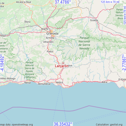
Lanjarón GPS coordinates[2]
36° 55' 6.708" North, 3° 28' 54.48" West
| Map corner | latitude | longitude |
|---|---|---|
| Upper-left | 37.4786°, | -4.18492° |
| Center: | 36.91853°, | -3.4818° |
| Lower-right: | 36.35432°, | -2.77867° |
| Map W x H: | 125×125 km | = 77.7×77.7mi |
| max Lat: | 43.74134° ⇑96% North |
| Lanjarón: | 36.91853° |
| min Lat: | ⇓4% South 27.64134° |
| min Long | Lanjarón | max Long |
| -18.00367° | -3.4818° | 4.2899° |
| W 48.2%⇐ | ⇒51.8% E |
Elevation
Elevation of Lanjarón is 667 m = 2188 ft, and this is 69 m = 226 ft above average elevation for this country.
| Max E: |
1682 m = 5518 ft | 49.2% |
| Lanjarón | 667 m 2188 ft | |
| Avg. | 598 m = 1962 ft | |
Min E: |
0 m = 0 ft | 50.8% |
See also: Spain elevation on elevation.city.
Geographical zone
Lanjarón is located in North temperate zone (between Tropic of Cancer and the Arctic Circle). Distance of this Northern Tropic circle is 1499 km =931.4 mi to South.| Distance of | km | miles | from Lanjarón |
|---|---|---|---|
| North Pole | 5902.1 | 3667.4 | to North |
| Arctic Circle | 3296.2 | 2048.2 | to North |
| Tropic Cancer | 1499 | 931.4 | to South |
| Equator | 4105 | 2550.7 | to South |


Nearby cities:
15 places around Lanjarón: (largest is in red/bold)
• Albuñuelas
13.4 km =8.3 mi,  274°
274°
• Almegíjar
16.2 km =10.1 mi,  96°
96°
• Bubión
11.7 km =7.3 mi,  73°
73°
• Busquístar
16.8 km =10.4 mi,  82°
82°
• Capileira
11.9 km =7.4 mi, 66°
• Carataunas
6.5 km =4 mi,  86°
86°
• Cáñar
4.9 km =3 mi, 79°
• Dúrcal
10.7 km =6.6 mi,  315°
315°
• Lújar
16 km =9.9 mi,  154°
154°
• Nigüelas
8.3 km =5.2 mi, 322°
• Pampaneira
11 km =6.8 mi, 77°
• Pórtugos
15.4 km =9.6 mi, 80°
• Soportújar
6.9 km =4.3 mi, 80°
• Vélez de Benaudalla
10 km =6.2 mi,  197°
197°
• Órgiva
5.5 km =3.4 mi,  108°
108°
Sources, notices
• [Note1] Compared only with cities in Spain existing in our database
• [Src1] Map data: © OpenStreetMap contributors (CC-BY-SA)
• [Src2] Other city data from geonames.org with taken over terms of usage.
• [Src3] Geographical zone / Annual Mean Temperature by Robert A. Rohde @ Wikipedia
