Valenzuela geodata
Valenzuela (Andalusia) is a seat of a third-order administrative division; located in Spain in Europe/Madrid (GMT+2) time zone. With population of 1,387 people, there are 2557 cities with bigger population in this country. Compared to other cities in Spain, 89.7% of cities are located further ↑North; 62.9% of cities are located further →East and 73.2% of cities have higher elevation than Valenzuela. Note1


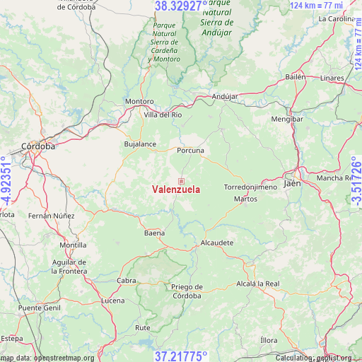
Valenzuela GPS coordinates[2]
37° 46' 32.16" North, 4° 13' 13.368" West
| Map corner | latitude | longitude |
|---|---|---|
| Upper-left | 38.32927°, | -4.92351° |
| Center: | 37.7756°, | -4.22038° |
| Lower-right: | 37.21775°, | -3.51726° |
| Map W x H: | 123.6×123.6 km | = 76.8×76.8mi |
| max Lat: | 43.74134° ⇑89.7% North |
| Valenzuela: | 37.7756° |
| min Lat: | ⇓10.3% South 27.64134° |
| min Long | Valenzuela | max Long |
| -18.00367° | -4.22038° | 4.2899° |
| W 37.1%⇐ | ⇒62.9% E |
Elevation
Elevation of Valenzuela is 327 m = 1073 ft, and this is 271 m = 889 ft below average elevation for this country.
| Max E: |
1682 m = 5518 ft | 73.2% |
| Avg. | 598 m = 1962 ft | |
| Valenzuela | 327 m = 1073 ft | |
Min E: |
0 m = 0 ft | 26.8% |
See also: Spain elevation on elevation.city.
Geographical zone
Valenzuela is located in North temperate zone (between Tropic of Cancer and the Arctic Circle). Distance of this Northern Tropic circle is 1594.3 km =990.7 mi to South.| Distance of | km | miles | from Valenzuela |
|---|---|---|---|
| North Pole | 5806.8 | 3608.2 | to North |
| Arctic Circle | 3200.9 | 1988.9 | to North |
| Tropic Cancer | 1594.3 | 990.7 | to South |
| Equator | 4200.3 | 2609.9 | to South |


Nearby cities:
15 places around Valenzuela: (largest is in red/bold)
• Alcaudete
23.9 km =14.9 mi,  149°
149°
• Arjona
22.9 km =14.2 mi,  39°
39°
• Arjonilla
24.2 km =15 mi,  24°
24°
• Baena
19.8 km =12.3 mi,  206°
206°
• Bujalance
19.4 km =12.1 mi,  313°
313°
• Cañete de las Torres
13.3 km =8.3 mi,  319°
319°
• Escañuela
20 km =12.4 mi,  54°
54°
• Higuera de Calatrava
6.1 km =3.8 mi,  65°
65°
• Lopera
18.9 km =11.7 mi,  1°
1°
• Martos
22.6 km =14 mi,  105°
105°
• Porcuna
11.1 km =6.9 mi, 16°
• Santiago de Calatrava
5 km =3.1 mi,  119°
119°
• Torredonjimeno
23.1 km =14.4 mi,  92°
92°
• Villa del Río
23.7 km =14.7 mi,  345°
345°
• Villardompardo
20.5 km =12.7 mi, 70°
Sources, notices
• [Note1] Compared only with cities in Spain existing in our database
• [Src1] Map data: © OpenStreetMap contributors (CC-BY-SA)
• [Src2] Other city data from geonames.org with taken over terms of usage.
• [Src3] Geographical zone / Annual Mean Temperature by Robert A. Rohde @ Wikipedia
