Alcaudete geodata
Alcaudete (Andalusia) is a seat of a third-order administrative division; located in Spain in Europe/Madrid (GMT+2) time zone. With population of 11,135 people, there are 792 cities with bigger population in this country. Compared to other cities in Spain, 90.8% of cities are located further ↑North; 61% of cities are located further →East and 51.2% of cities have lower elevation than Alcaudete. Note1


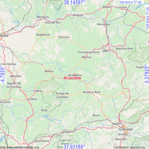
Alcaudete GPS coordinates[2]
37° 35' 27.276" North, 4° 4' 56.532" West
| Map corner | latitude | longitude |
|---|---|---|
| Upper-left | 38.14597°, | -4.7855° |
| Center: | 37.59091°, | -4.08237° |
| Lower-right: | 37.03168°, | -3.37925° |
| Map W x H: | 123.9×123.9 km | = 77×77mi |
| max Lat: | 43.74134° ⇑90.8% North |
| Alcaudete: | 37.59091° |
| min Lat: | ⇓9.2% South 27.64134° |
| min Long | Alcaudete | max Long |
| -18.00367° | -4.08237° | 4.2899° |
| W 39%⇐ | ⇒61% E |
Elevation
Elevation of Alcaudete is 672 m = 2205 ft, and this is 74 m = 243 ft above average elevation for this country.
| Max E: |
1682 m = 5518 ft | 48.8% |
| Alcaudete | 672 m 2205 ft | |
| Avg. | 598 m = 1962 ft | |
Min E: |
0 m = 0 ft | 51.2% |
See also: Spain elevation on elevation.city.
Geographical zone
Alcaudete is located in North temperate zone (between Tropic of Cancer and the Arctic Circle). Distance of this Northern Tropic circle is 1573.8 km =977.9 mi to South.| Distance of | km | miles | from Alcaudete |
|---|---|---|---|
| North Pole | 5827.3 | 3620.9 | to North |
| Arctic Circle | 3221.5 | 2001.7 | to North |
| Tropic Cancer | 1573.8 | 977.9 | to South |
| Equator | 4179.7 | 2597.1 | to South |


Nearby cities:
15 places around Alcaudete: (largest is in red/bold)
• Alcalá la Real
20.1 km =12.5 mi,  135°
135°
• Almedinilla
16.9 km =10.5 mi,  182°
182°
• Baena
21.3 km =13.2 mi,  277°
277°
• Carcabuey
23.5 km =14.6 mi,  226°
226°
• Castillo de Locubín
14.2 km =8.8 mi,  119°
119°
• Fuensanta de Martos
16.6 km =10.3 mi,  67°
67°
• Fuente-Tójar
10.5 km =6.5 mi,  212°
212°
• Jamilena
22.8 km =14.2 mi,  40°
40°
• Luque
17.8 km =11.1 mi,  258°
258°
• Martos
17.4 km =10.8 mi,  33°
33°
• Priego de Córdoba
19.7 km =12.2 mi, 210°
• Santiago de Calatrava
19.7 km =12.2 mi,  336°
336°
• Torredonjimeno
22.5 km =14 mi, 29°
• Valdepeñas de Jaén
23.6 km =14.7 mi,  90°
90°
• Zuheros
21.2 km =13.2 mi, 255°
Sources, notices
• [Note1] Compared only with cities in Spain existing in our database
• [Src1] Map data: © OpenStreetMap contributors (CC-BY-SA)
• [Src2] Other city data from geonames.org with taken over terms of usage.
• [Src3] Geographical zone / Annual Mean Temperature by Robert A. Rohde @ Wikipedia
