Baena geodata
Baena (Andalusia) is a seat of a third-order administrative division; located in Spain in Europe/Madrid (GMT+2) time zone. With population of 20,915 people, there are 457 cities with bigger population in this country. Compared to other cities in Spain, 90.5% of cities are located further ↑North; 64.1% of cities are located further →East and 68.3% of cities have higher elevation than Baena. Note1


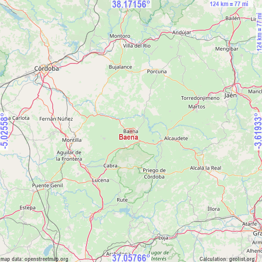
Baena GPS coordinates[2]
37° 37' 0.12" North, 4° 19' 20.82" West
| Map corner | latitude | longitude |
|---|---|---|
| Upper-left | 38.17156°, | -5.02558° |
| Center: | 37.6167°, | -4.32245° |
| Lower-right: | 37.05766°, | -3.61933° |
| Map W x H: | 123.9×123.9 km | = 77×77mi |
| max Lat: | 43.74134° ⇑90.5% North |
| Baena: | 37.6167° |
| min Lat: | ⇓9.5% South 27.64134° |
| min Long | Baena | max Long |
| -18.00367° | -4.32245° | 4.2899° |
| W 35.9%⇐ | ⇒64.1% E |
Elevation
Elevation of Baena is 412 m = 1352 ft, and this is 186 m = 610 ft below average elevation for this country.
| Max E: |
1682 m = 5518 ft | 68.3% |
| Avg. | 598 m = 1962 ft | |
| Baena | 412 m = 1352 ft | |
Min E: |
0 m = 0 ft | 31.7% |
See also: Spain elevation on elevation.city.
Geographical zone
Baena is located in North temperate zone (between Tropic of Cancer and the Arctic Circle). Distance of this Northern Tropic circle is 1576.7 km =979.7 mi to South.| Distance of | km | miles | from Baena |
|---|---|---|---|
| North Pole | 5824.5 | 3619.2 | to North |
| Arctic Circle | 3218.6 | 1999.9 | to North |
| Tropic Cancer | 1576.7 | 979.7 | to South |
| Equator | 4182.6 | 2598.9 | to South |


Nearby cities:
15 places around Baena: (largest is in red/bold)
• Alcaudete
21.3 km =13.2 mi,  97°
97°
• Cabra
19.2 km =11.9 mi,  213°
213°
• Carcabuey
19.6 km =12.2 mi,  167°
167°
• Castro del Río
16.2 km =10.1 mi,  300°
300°
• Doña Mencía
7.6 km =4.7 mi,  202°
202°
• Espejo
21.5 km =13.4 mi,  289°
289°
• Fuente-Tójar
19.5 km =12.1 mi,  127°
127°
• Higuera de Calatrava
24.9 km =15.5 mi,  35°
35°
• Lucena
27.2 km =16.9 mi, 211°
• Luque
7.5 km =4.7 mi,  150°
150°
• Nueva-Carteya
13.2 km =8.2 mi,  255°
255°
• Priego de Córdoba
22.8 km =14.2 mi, 150°
• Santiago de Calatrava
20.3 km =12.6 mi, 41°
• Valenzuela
19.8 km =12.3 mi,  26°
26°
• Zuheros
8.2 km =5.1 mi,  175°
175°
Sources, notices
• [Note1] Compared only with cities in Spain existing in our database
• [Src1] Map data: © OpenStreetMap contributors (CC-BY-SA)
• [Src2] Other city data from geonames.org with taken over terms of usage.
• [Src3] Geographical zone / Annual Mean Temperature by Robert A. Rohde @ Wikipedia
