Escañuela geodata
Escañuela (Andalusia) is a seat of a third-order administrative division; located in Spain in Europe/Madrid (GMT+2) time zone. With population of 930 people, there are 3038 cities with bigger population in this country. Compared to other cities in Spain, 89.2% of cities are located further ↑North; 60.2% of cities are located further →East and 73.9% of cities have higher elevation than Escañuela. Note1


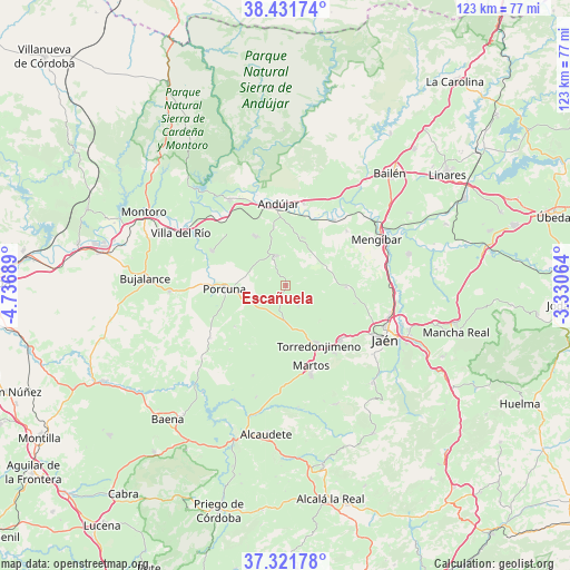
Escañuela GPS coordinates[2]
37° 52' 43.86" North, 4° 2' 1.536" West
| Map corner | latitude | longitude |
|---|---|---|
| Upper-left | 38.43174°, | -4.73689° |
| Center: | 37.87885°, | -4.03376° |
| Lower-right: | 37.32178°, | -3.33064° |
| Map W x H: | 123.4×123.4 km | = 76.7×76.7mi |
| max Lat: | 43.74134° ⇑89.2% North |
| Escañuela: | 37.87885° |
| min Lat: | ⇓10.8% South 27.64134° |
| min Long | Escañuela | max Long |
| -18.00367° | -4.03376° | 4.2899° |
| W 39.8%⇐ | ⇒60.2% E |
Elevation
Elevation of Escañuela is 317 m = 1040 ft, and this is 281 m = 922 ft below average elevation for this country.
| Max E: |
1682 m = 5518 ft | 73.9% |
| Avg. | 598 m = 1962 ft | |
| Escañuela | 317 m = 1040 ft | |
Min E: |
0 m = 0 ft | 26.1% |
See also: Spain elevation on elevation.city.
Geographical zone
Escañuela is located in North temperate zone (between Tropic of Cancer and the Arctic Circle). Distance of this Northern Tropic circle is 1605.8 km =997.8 mi to South.| Distance of | km | miles | from Escañuela |
|---|---|---|---|
| North Pole | 5795.3 | 3601 | to North |
| Arctic Circle | 3189.4 | 1981.8 | to North |
| Tropic Cancer | 1605.8 | 997.8 | to South |
| Equator | 4211.7 | 2617 | to South |


Nearby cities:
15 places around Escañuela: (largest is in red/bold)
• Andújar
17.9 km =11.1 mi,  355°
355°
• Arjona
6.5 km =4 mi,  343°
343°
• Arjonilla
12.4 km =7.7 mi,  328°
328°
• Cazalilla
17.6 km =10.9 mi,  48°
48°
• Fuerte del Rey
13.2 km =8.2 mi,  91°
91°
• Higuera de Arjona
10.9 km =6.8 mi,  20°
20°
• Higuera de Calatrava
14.1 km =8.8 mi,  230°
230°
• Jamilena
18 km =11.2 mi,  144°
144°
• Lopera
17.5 km =10.9 mi,  295°
295°
• Martos
18.3 km =11.4 mi,  162°
162°
• Porcuna
13.3 km =8.3 mi,  266°
266°
• Torre del Campo
17 km =10.6 mi, 135°
• Torredonjimeno
14.1 km =8.8 mi,  151°
151°
• Villanueva de la Reina
17.4 km =10.8 mi,  36°
36°
• Villardompardo
5.5 km =3.4 mi, 147°
Sources, notices
• [Note1] Compared only with cities in Spain existing in our database
• [Src1] Map data: © OpenStreetMap contributors (CC-BY-SA)
• [Src2] Other city data from geonames.org with taken over terms of usage.
• [Src3] Geographical zone / Annual Mean Temperature by Robert A. Rohde @ Wikipedia
