Martos geodata
Martos (Andalusia) is a seat of a third-order administrative division; located in Spain in Europe/Madrid (GMT+2) time zone. With population of 24,655 people, there are 379 cities with bigger population in this country. Compared to other cities in Spain, 90% of cities are located further ↑North; 59.3% of cities are located further →East and 50.2% of cities have lower elevation than Martos. Note1


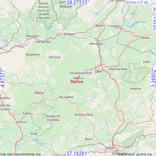
Martos GPS coordinates[2]
37° 43' 15.852" North, 3° 58' 21.504" West
| Map corner | latitude | longitude |
|---|---|---|
| Upper-left | 38.27515°, | -4.67577° |
| Center: | 37.72107°, | -3.97264° |
| Lower-right: | 37.16281°, | -3.26952° |
| Map W x H: | 123.7×123.7 km | = 76.9×76.9mi |
| max Lat: | 43.74134° ⇑90% North |
| Martos: | 37.72107° |
| min Lat: | ⇓10% South 27.64134° |
| min Long | Martos | max Long |
| -18.00367° | -3.97264° | 4.2899° |
| W 40.7%⇐ | ⇒59.3% E |
Elevation
Elevation of Martos is 661 m = 2169 ft, and this is 63 m = 207 ft above average elevation for this country.
| Max E: |
1682 m = 5518 ft | 49.8% |
| Martos | 661 m 2169 ft | |
| Avg. | 598 m = 1962 ft | |
Min E: |
0 m = 0 ft | 50.2% |
See also: Spain elevation on elevation.city.
Geographical zone
Martos is located in North temperate zone (between Tropic of Cancer and the Arctic Circle). Distance of this Northern Tropic circle is 1588.3 km =986.9 mi to South.| Distance of | km | miles | from Martos |
|---|---|---|---|
| North Pole | 5812.9 | 3612 | to North |
| Arctic Circle | 3207 | 1992.7 | to North |
| Tropic Cancer | 1588.3 | 986.9 | to South |
| Equator | 4194.2 | 2606.2 | to South |


Nearby cities:
15 places around Martos: (largest is in red/bold)
• Alcaudete
17.4 km =10.8 mi,  213°
213°
• Castillo de Locubín
21.6 km =13.4 mi,  172°
172°
• Escañuela
18.3 km =11.4 mi,  342°
342°
• Fuensanta de Martos
9.9 km =6.2 mi,  145°
145°
• Fuerte del Rey
18.8 km =11.7 mi,  24°
24°
• Higuera de Calatrava
18.4 km =11.4 mi,  297°
297°
• Jamilena
5.9 km =3.7 mi,  60°
60°
• Jaén
16.9 km =10.5 mi,  71°
71°
• Los Villares
13.9 km =8.6 mi,  103°
103°
• Santiago de Calatrava
17.8 km =11.1 mi,  281°
281°
• Torre del Campo
8.6 km =5.3 mi,  50°
50°
• Torredonjimeno
5.3 km =3.3 mi,  14°
14°
• Valdepeñas de Jaén
20.2 km =12.6 mi,  136°
136°
• Valenzuela
22.6 km =14 mi,  285°
285°
• Villardompardo
13.2 km =8.2 mi,  349°
349°
Sources, notices
• [Note1] Compared only with cities in Spain existing in our database
• [Src1] Map data: © OpenStreetMap contributors (CC-BY-SA)
• [Src2] Other city data from geonames.org with taken over terms of usage.
• [Src3] Geographical zone / Annual Mean Temperature by Robert A. Rohde @ Wikipedia
