Utiel geodata
Utiel (Valencia) is a seat of a third-order administrative division; located in Spain in Europe/Madrid (GMT+2) time zone. With population of 12,420 people, there are 732 cities with bigger population in this country. Compared to other cities in Spain, 76.2% of cities are located further ↑North; 75.7% of cities are located further ←West and 59.1% of cities have lower elevation than Utiel. Note1


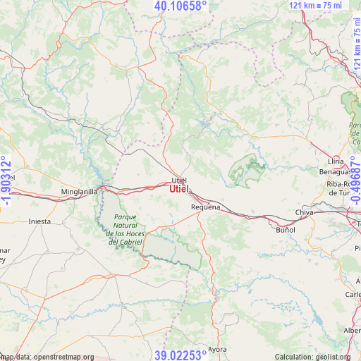
Utiel GPS coordinates[2]
39° 34' 0.012" North, 1° 12' 0" West
| Map corner | latitude | longitude |
|---|---|---|
| Upper-left | 40.10658°, | -1.90312° |
| Center: | 39.56667°, | -1.2° |
| Lower-right: | 39.02253°, | -0.49687° |
| Map W x H: | 120.5×120.5 km | = 74.9×74.9mi |
| max Lat: | 43.74134° ⇑76.2% North |
| Utiel: | 39.56667° |
| min Lat: | ⇓23.8% South 27.64134° |
| min Long | Utiel | max Long |
| -18.00367° | -1.2° | 4.2899° |
| W 75.7%⇐ | ⇒24.3% E |
Elevation
Elevation of Utiel is 738 m = 2421 ft, and this is 140 m = 459 ft above average elevation for this country.
| Max E: |
1682 m = 5518 ft | 40.9% |
| Utiel | 738 m 2421 ft | |
| Avg. | 598 m = 1962 ft | |
Min E: |
0 m = 0 ft | 59.1% |
See also: Spain elevation on elevation.city.
Geographical zone
Utiel is located in North temperate zone (between Tropic of Cancer and the Arctic Circle). Distance of this Northern Tropic circle is 1793.5 km =1114.4 mi to South.| Distance of | km | miles | from Utiel |
|---|---|---|---|
| North Pole | 5607.7 | 3484.5 | to North |
| Arctic Circle | 3001.8 | 1865.2 | to North |
| Tropic Cancer | 1793.5 | 1114.4 | to South |
| Equator | 4399.4 | 2733.7 | to South |


Nearby cities:
15 places around Utiel: (largest is in red/bold)
• Aliaguilla
22.2 km =13.8 mi,  331°
331°
• Benagéber
18.7 km =11.6 mi,  27°
27°
• Calles
26.1 km =16.2 mi,  48°
48°
• Camporrobles
19.5 km =12.1 mi,  298°
298°
• Caudete de las Fuentes
6.8 km =4.2 mi,  263°
263°
• Chelva
26.7 km =16.6 mi,  40°
40°
• Chera
20.3 km =12.6 mi,  79°
79°
• Fuenterrobles
13 km =8.1 mi,  278°
278°
• Mira
26 km =16.2 mi,  309°
309°
• Requena
12.2 km =7.6 mi,  135°
135°
• Sinarcas
18.7 km =11.6 mi,  351°
351°
• Sot de Chera
26.7 km =16.6 mi,  73°
73°
• Tuéjar
26.4 km =16.4 mi, 32°
• Venta del Moro
15.9 km =9.9 mi,  234°
234°
• Villargordo del Cabriel
20.3 km =12.6 mi, 259°
Sources, notices
• [Note1] Compared only with cities in Spain existing in our database
• [Src1] Map data: © OpenStreetMap contributors (CC-BY-SA)
• [Src2] Other city data from geonames.org with taken over terms of usage.
• [Src3] Geographical zone / Annual Mean Temperature by Robert A. Rohde @ Wikipedia
