Requena geodata
Requena (Valencia) is a seat of a third-order administrative division; located in Spain in Europe/Madrid (GMT+2) time zone. With population of 21,278 people, there are 450 cities with bigger population in this country. Compared to other cities in Spain, 77% of cities are located further ↑North; 76.3% of cities are located further ←West and 53.9% of cities have lower elevation than Requena. Note1


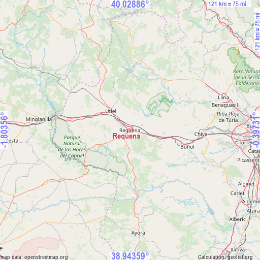
Requena GPS coordinates[2]
39° 29' 18.024" North, 1° 6' 1.584" West
| Map corner | latitude | longitude |
|---|---|---|
| Upper-left | 40.02886°, | -1.80356° |
| Center: | 39.48834°, | -1.10044° |
| Lower-right: | 38.94359°, | -0.39731° |
| Map W x H: | 120.7×120.7 km | = 75×75mi |
| max Lat: | 43.74134° ⇑77% North |
| Requena: | 39.48834° |
| min Lat: | ⇓23% South 27.64134° |
| min Long | Requena | max Long |
| -18.00367° | -1.10044° | 4.2899° |
| W 76.3%⇐ | ⇒23.7% E |
Elevation
Elevation of Requena is 699 m = 2293 ft, and this is 101 m = 331 ft above average elevation for this country.
| Max E: |
1682 m = 5518 ft | 46.1% |
| Requena | 699 m 2293 ft | |
| Avg. | 598 m = 1962 ft | |
Min E: |
0 m = 0 ft | 53.9% |
See also: Spain elevation on elevation.city.
Geographical zone
Requena is located in North temperate zone (between Tropic of Cancer and the Arctic Circle). Distance of this Northern Tropic circle is 1784.8 km =1109 mi to South.| Distance of | km | miles | from Requena |
|---|---|---|---|
| North Pole | 5616.4 | 3489.9 | to North |
| Arctic Circle | 3010.5 | 1870.6 | to North |
| Tropic Cancer | 1784.8 | 1109 | to South |
| Equator | 4390.7 | 2728.3 | to South |


Nearby cities:
15 places around Requena: (largest is in red/bold)
• Balsa de Ves
26.1 km =16.2 mi,  199°
199°
• Benagéber
25.4 km =15.8 mi,  0°
0°
• Calles
28.2 km =17.5 mi,  23°
23°
• Caudete de las Fuentes
17.2 km =10.7 mi,  297°
297°
• Chera
16.9 km =10.5 mi,  42°
42°
• Chulilla
25.9 km =16.1 mi,  45°
45°
• Fuenterrobles
23.9 km =14.9 mi, 296°
• Gestalgar
26.1 km =16.2 mi,  61°
61°
• Loriguilla
26.8 km =16.7 mi, 35°
• Siete Aguas
16 km =9.9 mi,  98°
98°
• Sot de Chera
23.6 km =14.7 mi, 46°
• Utiel
12.2 km =7.6 mi,  315°
315°
• Venta del Moro
21.4 km =13.3 mi,  268°
268°
• Villatoya
24.3 km =15.1 mi,  224°
224°
• Yátova
28.3 km =17.6 mi,  114°
114°
Sources, notices
• [Note1] Compared only with cities in Spain existing in our database
• [Src1] Map data: © OpenStreetMap contributors (CC-BY-SA)
• [Src2] Other city data from geonames.org with taken over terms of usage.
• [Src3] Geographical zone / Annual Mean Temperature by Robert A. Rohde @ Wikipedia
