Tous geodata
Tous (Valencia) is a seat of a third-order administrative division; located in Spain in Europe/Madrid (GMT+2) time zone. With population of 1,114 people, there are 2808 cities with bigger population in this country. Compared to other cities in Spain, 79.9% of cities are located further ↑North; 80.7% of cities are located further ←West and 87.8% of cities have higher elevation than Tous. Note1


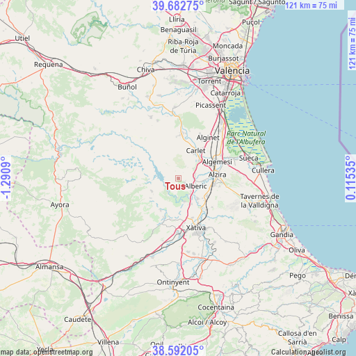
Tous GPS coordinates[2]
39° 8' 22.236" North, 0° 35' 15.972" West
| Map corner | latitude | longitude |
|---|---|---|
| Upper-left | 39.68275°, | -1.2909° |
| Center: | 39.13951°, | -0.58777° |
| Lower-right: | 38.59205°, | 0.11535° |
| Map W x H: | 121.3×121.3 km | = 75.4×75.4mi |
| max Lat: | 43.74134° ⇑79.9% North |
| Tous: | 39.13951° |
| min Lat: | ⇓20.1% South 27.64134° |
| min Long | Tous | max Long |
| -18.00367° | -0.58777° | 4.2899° |
| W 80.7%⇐ | ⇒19.3% E |
Elevation
Elevation of Tous is 98 m = 322 ft, and this is 500 m = 1640 ft below average elevation for this country.
| Max E: |
1682 m = 5518 ft | 87.8% |
| Avg. | 598 m = 1962 ft | |
| Tous | 98 m = 322 ft | |
Min E: |
0 m = 0 ft | 12.2% |
See also: Spain elevation on elevation.city.
Geographical zone
Tous is located in North temperate zone (between Tropic of Cancer and the Arctic Circle). Distance of this Northern Tropic circle is 1746 km =1084.9 mi to South.| Distance of | km | miles | from Tous |
|---|---|---|---|
| North Pole | 5655.2 | 3514 | to North |
| Arctic Circle | 3049.3 | 1894.7 | to North |
| Tropic Cancer | 1746 | 1084.9 | to South |
| Equator | 4351.9 | 2704.1 | to South |


Nearby cities:
15 places around Tous: (largest is in red/bold)
• Alberic
6.6 km =4.1 mi,  112°
112°
• Alcàntera de Xúquer
8.7 km =5.4 mi,  158°
158°
• Antella
6.7 km =4.2 mi,  183°
183°
• Beneixida
8.7 km =5.4 mi, 158°
• Benimodo
9.8 km =6.1 mi,  32°
32°
• Benimuslem
8.2 km =5.1 mi,  96°
96°
• Cotes
7.8 km =4.8 mi,  171°
171°
• Càrcer
8.3 km =5.2 mi, 167°
• Gavarda
7 km =4.3 mi,  152°
152°
• Guadassuar
10.8 km =6.7 mi,  60°
60°
• L'Alcúdia
9.6 km =6 mi,  47°
47°
• Masalavés
5.6 km =3.5 mi,  85°
85°
• Navarrés
10.1 km =6.3 mi,  245°
245°
• Sumacàrcer
5.9 km =3.7 mi,  221°
221°
• Villanueva de Castellón
9.5 km =5.9 mi,  136°
136°
Sources, notices
• [Note1] Compared only with cities in Spain existing in our database
• [Src1] Map data: © OpenStreetMap contributors (CC-BY-SA)
• [Src2] Other city data from geonames.org with taken over terms of usage.
• [Src3] Geographical zone / Annual Mean Temperature by Robert A. Rohde @ Wikipedia
