Cotes geodata
Cotes (Valencia) is a seat of a third-order administrative division; located in Spain in Europe/Madrid (GMT+2) time zone. With population of 363 people, there are 4269 cities with bigger population in this country. Compared to other cities in Spain, 80.4% of cities are located further ↑North; 80.9% of cities are located further ←West and 91.9% of cities have higher elevation than Cotes. Note1


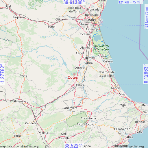
Cotes GPS coordinates[2]
39° 4' 12.36" North, 0° 34' 28.164" West
| Map corner | latitude | longitude |
|---|---|---|
| Upper-left | 39.61388°, | -1.27762° |
| Center: | 39.0701°, | -0.57449° |
| Lower-right: | 38.5221°, | 0.12863° |
| Map W x H: | 121.4×121.4 km | = 75.4×75.4mi |
| max Lat: | 43.74134° ⇑80.4% North |
| Cotes: | 39.0701° |
| min Lat: | ⇓19.6% South 27.64134° |
| min Long | Cotes | max Long |
| -18.00367° | -0.57449° | 4.2899° |
| W 80.9%⇐ | ⇒19.1% E |
Elevation
Elevation of Cotes is 45 m = 148 ft, and this is 553 m = 1814 ft below average elevation for this country.
| Max E: |
1682 m = 5518 ft | 91.9% |
| Avg. | 598 m = 1962 ft | |
| Cotes | 45 m = 148 ft | |
Min E: |
0 m = 0 ft | 8.1% |
See also: Spain elevation on elevation.city.
Geographical zone
Cotes is located in North temperate zone (between Tropic of Cancer and the Arctic Circle). Distance of this Northern Tropic circle is 1738.3 km =1080.1 mi to South.| Distance of | km | miles | from Cotes |
|---|---|---|---|
| North Pole | 5662.9 | 3518.8 | to North |
| Arctic Circle | 3057 | 1899.5 | to North |
| Tropic Cancer | 1738.3 | 1080.1 | to South |
| Equator | 4344.2 | 2699.4 | to South |


Nearby cities:
15 places around Cotes: (largest is in red/bold)
• Alberic
7.2 km =4.5 mi,  43°
43°
• Alcàntera de Xúquer
2.1 km =1.3 mi,  100°
100°
• Antella
1.9 km =1.2 mi,  305°
305°
• Beneixida
2.1 km =1.3 mi, 100°
• Càrcer
0.8 km =0.5 mi,  119°
119°
• Estubeny
7.2 km =4.5 mi,  216°
216°
• Gavarda
2.6 km =1.6 mi,  55°
55°
• Llosa de Ranes
6.2 km =3.9 mi,  149°
149°
• Manuel
7.6 km =4.7 mi,  106°
106°
• Rotglá y Corbera
7.3 km =4.5 mi,  173°
173°
• San Juan de Énova
7.5 km =4.7 mi,  89°
89°
• Sellent
4.4 km =2.7 mi,  195°
195°
• Senyera
6.4 km =4 mi, 93°
• Sumacàrcer
6.1 km =3.8 mi,  303°
303°
• Villanueva de Castellón
5.5 km =3.4 mi,  81°
81°
Sources, notices
• [Note1] Compared only with cities in Spain existing in our database
• [Src1] Map data: © OpenStreetMap contributors (CC-BY-SA)
• [Src2] Other city data from geonames.org with taken over terms of usage.
• [Src3] Geographical zone / Annual Mean Temperature by Robert A. Rohde @ Wikipedia
