Antella geodata
Antella (Valencia) is a seat of a third-order administrative division; located in Spain in Europe/Madrid (GMT+2) time zone. With population of 1,498 people, there are 2463 cities with bigger population in this country. Compared to other cities in Spain, 80.3% of cities are located further ↑North; 80.6% of cities are located further ←West and 91.1% of cities have higher elevation than Antella. Note1


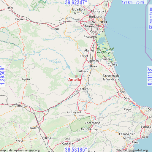
Antella GPS coordinates[2]
39° 4' 47.172" North, 0° 35' 31.02" West
| Map corner | latitude | longitude |
|---|---|---|
| Upper-left | 39.62347°, | -1.29508° |
| Center: | 39.07977°, | -0.59195° |
| Lower-right: | 38.53185°, | 0.11118° |
| Map W x H: | 121.4×121.4 km | = 75.4×75.4mi |
| max Lat: | 43.74134° ⇑80.3% North |
| Antella: | 39.07977° |
| min Lat: | ⇓19.7% South 27.64134° |
| min Long | Antella | max Long |
| -18.00367° | -0.59195° | 4.2899° |
| W 80.6%⇐ | ⇒19.4% E |
Elevation
Elevation of Antella is 51 m = 167 ft, and this is 547 m = 1795 ft below average elevation for this country.
| Max E: |
1682 m = 5518 ft | 91.1% |
| Avg. | 598 m = 1962 ft | |
| Antella | 51 m = 167 ft | |
Min E: |
0 m = 0 ft | 8.9% |
See also: Spain elevation on elevation.city.
Geographical zone
Antella is located in North temperate zone (between Tropic of Cancer and the Arctic Circle). Distance of this Northern Tropic circle is 1739.3 km =1080.8 mi to South.| Distance of | km | miles | from Antella |
|---|---|---|---|
| North Pole | 5661.8 | 3518.1 | to North |
| Arctic Circle | 3055.9 | 1898.8 | to North |
| Tropic Cancer | 1739.3 | 1080.8 | to South |
| Equator | 4345.3 | 2700 | to South |


Nearby cities:
15 places around Antella: (largest is in red/bold)
• Alberic
7.7 km =4.8 mi,  57°
57°
• Alcàntera de Xúquer
3.9 km =2.4 mi,  111°
111°
• Beneixida
3.9 km =2.4 mi, 111°
• Bolbaite
7.5 km =4.7 mi,  253°
253°
• Chella
7.2 km =4.5 mi,  234°
234°
• Cotes
1.9 km =1.2 mi,  125°
125°
• Càrcer
2.6 km =1.6 mi,  123°
123°
• Estubeny
7.4 km =4.6 mi,  201°
201°
• Gavarda
3.6 km =2.2 mi,  83°
83°
• Llosa de Ranes
8 km =5 mi,  144°
144°
• Sellent
5.3 km =3.3 mi,  176°
176°
• Senyera
8.1 km =5 mi,  100°
100°
• Sumacàrcer
4.2 km =2.6 mi,  302°
302°
• Tous
6.7 km =4.2 mi,  3°
3°
• Villanueva de Castellón
6.9 km =4.3 mi,  92°
92°
Sources, notices
• [Note1] Compared only with cities in Spain existing in our database
• [Src1] Map data: © OpenStreetMap contributors (CC-BY-SA)
• [Src2] Other city data from geonames.org with taken over terms of usage.
• [Src3] Geographical zone / Annual Mean Temperature by Robert A. Rohde @ Wikipedia
