Tíjola geodata
Tíjola (Andalusia) is a populated place; located in Spain in Europe/Madrid (GMT+2) time zone. With population of 3,724 people, there are 1534 cities with bigger population in this country. Compared to other cities in Spain, 92.5% of cities are located further ↑North; 61.8% of cities are located further ←West and 52.9% of cities have lower elevation than Tíjola. Note1


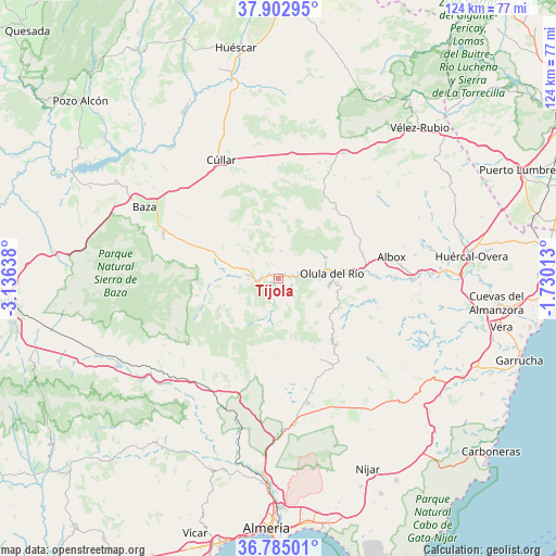
Tíjola GPS coordinates[2]
37° 20' 45.816" North, 2° 25' 59.736" West
| Map corner | latitude | longitude |
|---|---|---|
| Upper-left | 37.90295°, | -3.13638° |
| Center: | 37.34606°, | -2.43326° |
| Lower-right: | 36.78501°, | -1.73013° |
| Map W x H: | 124.3×124.3 km | = 77.2×77.2mi |
| max Lat: | 43.74134° ⇑92.5% North |
| Tíjola: | 37.34606° |
| min Lat: | ⇓7.5% South 27.64134° |
| min Long | Tíjola | max Long |
| -18.00367° | -2.43326° | 4.2899° |
| W 61.8%⇐ | ⇒38.2% E |
Elevation
Elevation of Tíjola is 689 m = 2260 ft, and this is 91 m = 299 ft above average elevation for this country.
| Max E: |
1682 m = 5518 ft | 47.1% |
| Tíjola | 689 m 2260 ft | |
| Avg. | 598 m = 1962 ft | |
Min E: |
0 m = 0 ft | 52.9% |
See also: Spain elevation on elevation.city.
Geographical zone
Tíjola is located in North temperate zone (between Tropic of Cancer and the Arctic Circle). Distance of this Northern Tropic circle is 1546.6 km =961 mi to South.| Distance of | km | miles | from Tíjola |
|---|---|---|---|
| North Pole | 5854.6 | 3637.9 | to North |
| Arctic Circle | 3248.7 | 2018.6 | to North |
| Tropic Cancer | 1546.6 | 961 | to South |
| Equator | 4152.5 | 2580.2 | to South |


Nearby cities:
15 places around Tíjola: (largest is in red/bold)
• Alcóntar
14.5 km =9 mi,  265°
265°
• Armuña de Almanzora
2 km =1.2 mi,  76°
76°
• Bayarque
1.7 km =1.1 mi,  188°
188°
• Fines
15.6 km =9.7 mi, 83°
• La Mojonera
6 km =3.7 mi,  183°
183°
• Laroya
10.3 km =6.4 mi,  121°
121°
• Lúcar
6.1 km =3.8 mi,  6°
6°
• Macael
11.8 km =7.3 mi,  96°
96°
• Olula del Río
12 km =7.5 mi,  85°
85°
• Purchena
6.4 km =4 mi, 88°
• Serón
6.7 km =4.2 mi, 268°
• Sierro
4.1 km =2.5 mi,  130°
130°
• Somontín
6.5 km =4 mi,  38°
38°
• Suflí
4.1 km =2.5 mi, 101°
• Urrácal
8.3 km =5.2 mi,  46°
46°
Sources, notices
• [Note1] Compared only with cities in Spain existing in our database
• [Src1] Map data: © OpenStreetMap contributors (CC-BY-SA)
• [Src2] Other city data from geonames.org with taken over terms of usage.
• [Src3] Geographical zone / Annual Mean Temperature by Robert A. Rohde @ Wikipedia
