La Mojonera geodata
La Mojonera (Andalusia) is a populated place; located in Spain in Europe/Madrid (GMT+2) time zone. With population of 7,819 people, there are 954 cities with bigger population in this country. Compared to other cities in Spain, 93% of cities are located further ↑North; 61.7% of cities are located further ←West and 93.5% of cities have lower elevation than La Mojonera. Note1


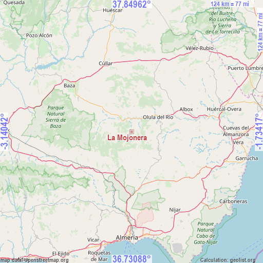
La Mojonera GPS coordinates[2]
37° 17' 32.388" North, 2° 26' 14.28" West
| Map corner | latitude | longitude |
|---|---|---|
| Upper-left | 37.84962°, | -3.14042° |
| Center: | 37.29233°, | -2.4373° |
| Lower-right: | 36.73088°, | -1.73417° |
| Map W x H: | 124.4×124.4 km | = 77.3×77.3mi |
| max Lat: | 43.74134° ⇑93% North |
| La Mojonera: | 37.29233° |
| min Lat: | ⇓7% South 27.64134° |
| min Long | La Mojonera | max Long |
| -18.00367° | -2.4373° | 4.2899° |
| W 61.7%⇐ | ⇒38.3% E |
Elevation
Elevation of La Mojonera is 1106 m = 3629 ft, and this is 508 m = 1667 ft above average elevation for this country.
| Max E: |
1682 m = 5518 ft | 6.5% |
| La Mojonera | 1106 m 3629 ft | |
| Avg. | 598 m = 1962 ft | |
Min E: |
0 m = 0 ft | 93.5% |
See also: Spain elevation on elevation.city.
Geographical zone
La Mojonera is located in North temperate zone (between Tropic of Cancer and the Arctic Circle). Distance of this Northern Tropic circle is 1540.6 km =957.3 mi to South.| Distance of | km | miles | from La Mojonera |
|---|---|---|---|
| North Pole | 5860.5 | 3641.5 | to North |
| Arctic Circle | 3254.7 | 2022.4 | to North |
| Tropic Cancer | 1540.6 | 957.3 | to South |
| Equator | 4146.5 | 2576.5 | to South |


Nearby cities:
15 places around La Mojonera: (largest is in red/bold)
• Armuña de Almanzora
6.8 km =4.2 mi,  19°
19°
• Bayarque
4.3 km =2.7 mi,  1°
1°
• Castro de Filabres
12 km =7.5 mi,  181°
181°
• Laroya
9.1 km =5.7 mi,  86°
86°
• Lúcar
12.1 km =7.5 mi,  5°
5°
• Macael
12.9 km =8 mi,  69°
69°
• Olula de Castro
13.5 km =8.4 mi,  194°
194°
• Purchena
9.1 km =5.7 mi,  47°
47°
• Serón
8.6 km =5.3 mi,  312°
312°
• Sierro
4.8 km =3 mi, 45°
• Somontín
11.9 km =7.4 mi, 21°
• Suflí
6.7 km =4.2 mi,  40°
40°
• Tíjola
6 km =3.7 mi, 3°
• Urrácal
13.3 km =8.3 mi,  28°
28°
• Velefique
11.4 km =7.1 mi,  163°
163°
Sources, notices
• [Note1] Compared only with cities in Spain existing in our database
• [Src1] Map data: © OpenStreetMap contributors (CC-BY-SA)
• [Src2] Other city data from geonames.org with taken over terms of usage.
• [Src3] Geographical zone / Annual Mean Temperature by Robert A. Rohde @ Wikipedia
