Laroya geodata
Laroya (Andalusia) is a seat of a third-order administrative division; located in Spain in Europe/Madrid (GMT+2) time zone. With population of 141 people, there are 5493 cities with bigger population in this country. Compared to other cities in Spain, 93% of cities are located further ↑North; 63% of cities are located further ←West and 88.7% of cities have lower elevation than Laroya. Note1


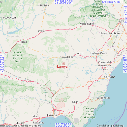
Laroya GPS coordinates[2]
37° 17' 51.756" North, 2° 20' 3.084" West
| Map corner | latitude | longitude |
|---|---|---|
| Upper-left | 37.85496°, | -3.03732° |
| Center: | 37.29771°, | -2.33419° |
| Lower-right: | 36.7363°, | -1.63107° |
| Map W x H: | 124.4×124.4 km | = 77.3×77.3mi |
| max Lat: | 43.74134° ⇑93% North |
| Laroya: | 37.29771° |
| min Lat: | ⇓7% South 27.64134° |
| min Long | Laroya | max Long |
| -18.00367° | -2.33419° | 4.2899° |
| W 63%⇐ | ⇒37% E |
Elevation
Elevation of Laroya is 1009 m = 3310 ft, and this is 411 m = 1348 ft above average elevation for this country.
| Max E: |
1682 m = 5518 ft | 11.3% |
| Laroya | 1009 m 3310 ft | |
| Avg. | 598 m = 1962 ft | |
Min E: |
0 m = 0 ft | 88.7% |
See also: Spain elevation on elevation.city.
Geographical zone
Laroya is located in North temperate zone (between Tropic of Cancer and the Arctic Circle). Distance of this Northern Tropic circle is 1541.2 km =957.7 mi to South.| Distance of | km | miles | from Laroya |
|---|---|---|---|
| North Pole | 5859.9 | 3641.2 | to North |
| Arctic Circle | 3254.1 | 2022 | to North |
| Tropic Cancer | 1541.2 | 957.7 | to South |
| Equator | 4147.1 | 2576.9 | to South |


Nearby cities:
15 places around Laroya: (largest is in red/bold)
• Alcudia de Monteagud
9.2 km =5.7 mi,  139°
139°
• Armuña de Almanzora
9 km =5.6 mi,  310°
310°
• Bayarque
9.7 km =6 mi,  292°
292°
• Benitagla
11.2 km =7 mi,  131°
131°
• Chercos
7.7 km =4.8 mi, 128°
• Fines
9.7 km =6 mi,  43°
43°
• La Mojonera
9.1 km =5.7 mi,  266°
266°
• Macael
4.9 km =3 mi, 36°
• Olula del Río
7.1 km =4.4 mi,  27°
27°
• Purchena
6 km =3.7 mi,  336°
336°
• Sierro
6.3 km =3.9 mi,  295°
295°
• Suflí
6.6 km =4.1 mi, 313°
• Tahal
8.9 km =5.5 mi,  150°
150°
• Tíjola
10.3 km =6.4 mi, 301°
• Urrácal
11.4 km =7.1 mi,  346°
346°
Sources, notices
• [Note1] Compared only with cities in Spain existing in our database
• [Src1] Map data: © OpenStreetMap contributors (CC-BY-SA)
• [Src2] Other city data from geonames.org with taken over terms of usage.
• [Src3] Geographical zone / Annual Mean Temperature by Robert A. Rohde @ Wikipedia
