Telde geodata
Telde (Canary Islands) is a seat of a third-order administrative division; located in Spain in Atlantic/Canary (GMT+1) time zone. With population of 100,015 people, there are 89 cities with bigger population in this country. Compared to other cities in Spain, 99.8% of cities are located further ↑North; 98.8% of cities are located further →East and 83.6% of cities have higher elevation than Telde. Note1


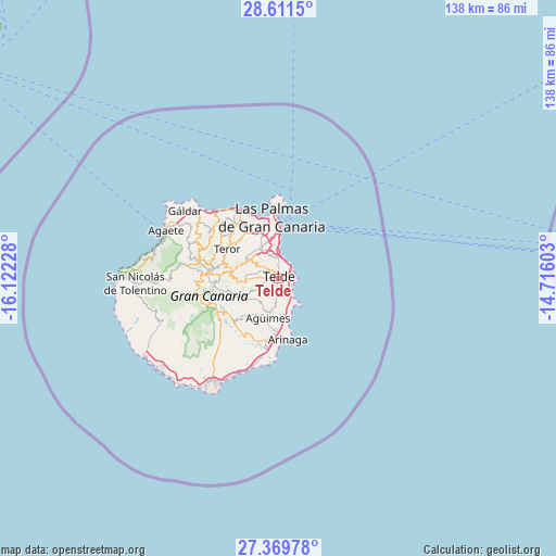
Telde GPS coordinates[2]
27° 59' 32.748" North, 15° 25' 8.94" West
| Map corner | latitude | longitude |
|---|---|---|
| Upper-left | 28.6115°, | -16.12228° |
| Center: | 27.99243°, | -15.41915° |
| Lower-right: | 27.36978°, | -14.71603° |
| Map W x H: | 138.1×138.1 km | = 85.8×85.8mi |
| max Lat: | 43.74134° ⇑99.8% North |
| Telde: | 27.99243° |
| min Lat: | ⇓0.2% South 27.64134° |
| min Long | Telde | max Long |
| -18.00367° | -15.41915° | 4.2899° |
| W 1.2%⇐ | ⇒98.8% E |
Elevation
Elevation of Telde is 160 m = 525 ft, and this is 438 m = 1437 ft below average elevation for this country.
| Max E: |
1682 m = 5518 ft | 83.6% |
| Avg. | 598 m = 1962 ft | |
| Telde | 160 m = 525 ft | |
Min E: |
0 m = 0 ft | 16.4% |
See also: Telde elevation on elevation.city.
Geographical zone
Telde is located in North temperate zone (between Tropic of Cancer and the Arctic Circle). Distance of this Northern Tropic circle is 506.5 km =314.7 mi to South.| Distance of | km | miles | from Telde |
|---|---|---|---|
| North Pole | 6894.6 | 4284.1 | to North |
| Arctic Circle | 4288.7 | 2664.9 | to North |
| Tropic Cancer | 506.5 | 314.7 | to South |
| Equator | 3112.5 | 1934 | to South |


Nearby cities:
15 places around Telde: (largest is in red/bold)
• Agüimes
10 km =6.2 mi,  195°
195°
• Arucas
17.5 km =10.9 mi,  324°
324°
• Carrizal
9.1 km =5.7 mi,  171°
171°
• Cruce de Arinaga
12.9 km =8 mi,  183°
183°
• Firgas
19 km =11.8 mi,  312°
312°
• Ingenio
8.3 km =5.2 mi,  190°
190°
• Las Palmas de Gran Canaria
11.9 km =7.4 mi,  2°
2°
• San Bartolomé de Tirajana
16.9 km =10.5 mi,  243°
243°
• Santa Brígida
9.4 km =5.8 mi,  297°
297°
• Santa Lucía
14.9 km =9.3 mi,  233°
233°
• Teror
14.8 km =9.2 mi, 300°
• Valleseco
16.4 km =10.2 mi,  290°
290°
• Valsequillo de Gran Canaria
7.7 km =4.8 mi,  264°
264°
• Vecindario
16.4 km =10.2 mi, 188°
• Vega de San Mateo
11.4 km =7.1 mi,  279°
279°
Sources, notices
• [Note1] Compared only with cities in Spain existing in our database
• [Src1] Map data: © OpenStreetMap contributors (CC-BY-SA)
• [Src2] Other city data from geonames.org with taken over terms of usage.
• [Src3] Geographical zone / Annual Mean Temperature by Robert A. Rohde @ Wikipedia
