Arucas geodata
Arucas (Canary Islands) is a seat of a third-order administrative division; located in Spain in Atlantic/Canary (GMT+1) time zone. With population of 36,259 people, there are 243 cities with bigger population in this country. Compared to other cities in Spain, 99.5% of cities are located further ↑North; 98.9% of cities are located further →East and 76.4% of cities have higher elevation than Arucas. Note1
Administrative division(s):
- Level 1: Canary Islands
- Level 2: Provincia de Las Palmas
- Level 3: Arucas


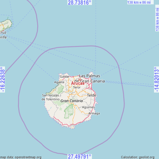
Arucas GPS coordinates[2]
28° 7' 11.388" North, 15° 31' 23.7" West
| Map corner | latitude | longitude |
|---|---|---|
| Upper-left | 28.73816°, | -16.22638° |
| Center: | 28.11983°, | -15.52325° |
| Lower-right: | 27.49791°, | -14.82013° |
| Map W x H: | 137.9×137.9 km | = 85.7×85.7mi |
| max Lat: | 43.74134° ⇑99.5% North |
| Arucas: | 28.11983° |
| min Lat: | ⇓0.5% South 27.64134° |
| min Long | Arucas | max Long |
| -18.00367° | -15.52325° | 4.2899° |
| W 1.1%⇐ | ⇒98.9% E |
Elevation
Elevation of Arucas is 280 m = 919 ft, and this is 318 m = 1043 ft below average elevation for this country.
| Max E: |
1682 m = 5518 ft | 76.4% |
| Avg. | 598 m = 1962 ft | |
| Arucas | 280 m = 919 ft | |
Min E: |
0 m = 0 ft | 23.6% |
See also: Spain elevation on elevation.city.
Geographical zone
Arucas is located in North temperate zone (between Tropic of Cancer and the Arctic Circle). Distance of this Northern Tropic circle is 520.7 km =323.5 mi to South.| Distance of | km | miles | from Arucas |
|---|---|---|---|
| North Pole | 6880.4 | 4275.3 | to North |
| Arctic Circle | 4274.5 | 2656.1 | to North |
| Tropic Cancer | 520.7 | 323.5 | to South |
| Equator | 3126.6 | 1942.8 | to South |


Nearby cities:
15 places around Arucas: (largest is in red/bold)
• Agaete
17.5 km =10.9 mi,  262°
262°
• Artenara
16.4 km =10.2 mi,  227°
227°
• Firgas
4.1 km =2.5 mi,  250°
250°
• Guia
11 km =6.8 mi,  281°
281°
• Gáldar
12.8 km =8 mi, 283°
• Las Palmas de Gran Canaria
11 km =6.8 mi,  101°
101°
• Moya
5.9 km =3.7 mi, 260°
• San Bartolomé de Tirajana
22.2 km =13.8 mi,  192°
192°
• Santa Brígida
9.9 km =6.2 mi,  169°
169°
• Tejeda
16.6 km =10.3 mi,  213°
213°
• Telde
17.5 km =10.9 mi,  144°
144°
• Teror
7.1 km =4.4 mi,  201°
201°
• Valleseco
10 km =6.2 mi, 211°
• Valsequillo de Gran Canaria
15.1 km =9.4 mi, 170°
• Vega de San Mateo
12.4 km =7.7 mi,  184°
184°
Sources, notices
• [Note1] Compared only with cities in Spain existing in our database
• [Src1] Map data: © OpenStreetMap contributors (CC-BY-SA)
• [Src2] Other city data from geonames.org with taken over terms of usage.
• [Src3] Geographical zone / Annual Mean Temperature by Robert A. Rohde @ Wikipedia
