Firgas geodata
Firgas (Canary Islands) is a seat of a third-order administrative division; located in Spain in Atlantic/Canary (GMT+1) time zone. With population of 7,106 people, there are 1023 cities with bigger population in this country. Compared to other cities in Spain, 99.5% of cities are located further ↑North; 99% of cities are located further →East and 61.1% of cities have higher elevation than Firgas. Note1
Administrative division(s):
- Level 1: Canary Islands
- Level 2: Provincia de Las Palmas
- Level 3: Firgas


Firgas GPS coordinates[2]
28° 6' 25.596" North, 15° 33' 46.764" West
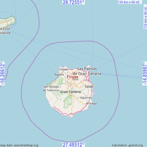
| Map corner | latitude | longitude |
|---|---|---|
| Upper-left | 28.72551°, | -16.26612° |
| Center: | 28.10711°, | -15.56299° |
| Lower-right: | 27.48512°, | -14.85987° |
| Map W x H: | 137.9×137.9 km | = 85.7×85.7mi |
| max Lat: | 43.74134° ⇑99.5% North |
| Firgas: | 28.10711° |
| min Lat: | ⇓0.5% South 27.64134° |
| min Long | Firgas | max Long |
| -18.00367° | -15.56299° | 4.2899° |
| W 1%⇐ | ⇒99% E |
Elevation
Elevation of Firgas is 510 m = 1673 ft, and this is 88 m = 289 ft below average elevation for this country.
| Max E: |
1682 m = 5518 ft | 61.1% |
| Avg. | 598 m = 1962 ft | |
| Firgas | 510 m = 1673 ft | |
Min E: |
0 m = 0 ft | 38.9% |
See also: Spain elevation on elevation.city.
Geographical zone
Firgas is located in North temperate zone (between Tropic of Cancer and the Arctic Circle). Distance of this Northern Tropic circle is 519.3 km =322.7 mi to South.| Distance of | km | miles | from Firgas |
|---|---|---|---|
| North Pole | 6881.8 | 4276.2 | to North |
| Arctic Circle | 4276 | 2657 | to North |
| Tropic Cancer | 519.3 | 322.7 | to South |
| Equator | 3125.2 | 1941.9 | to South |


Nearby cities:
15 places around Firgas: (largest is in red/bold)
• Agaete
13.5 km =8.4 mi,  266°
266°
• Artenara
12.7 km =7.9 mi,  220°
220°
• Arucas
4.1 km =2.5 mi,  70°
70°
• Guia
7.8 km =4.8 mi,  297°
297°
• Gáldar
9.6 km =6 mi, 297°
• Las Palmas de Gran Canaria
14.7 km =9.1 mi,  93°
93°
• Moya
2 km =1.2 mi,  282°
282°
• San Bartolomé de Tirajana
20.3 km =12.6 mi,  182°
182°
• Santa Brígida
10.1 km =6.3 mi,  145°
145°
• Tejeda
13.5 km =8.4 mi,  202°
202°
• Telde
19 km =11.8 mi,  132°
132°
• Teror
5.3 km =3.3 mi,  165°
165°
• Valleseco
7.2 km =4.5 mi,  190°
190°
• Valsequillo de Gran Canaria
15 km =9.3 mi, 154°
• Vega de San Mateo
11.3 km =7 mi, 165°
Sources, notices
• [Note1] Compared only with cities in Spain existing in our database
• [Src1] Map data: © OpenStreetMap contributors (CC-BY-SA)
• [Src2] Other city data from geonames.org with taken over terms of usage.
• [Src3] Geographical zone / Annual Mean Temperature by Robert A. Rohde @ Wikipedia
