Teror geodata
Teror (Canary Islands) is a seat of a third-order administrative division; located in Spain in Atlantic/Canary (GMT+1) time zone. With population of 12,926 people, there are 708 cities with bigger population in this country. Compared to other cities in Spain, 99.6% of cities are located further ↑North; 98.9% of cities are located further →East and 52.2% of cities have higher elevation than Teror. Note1


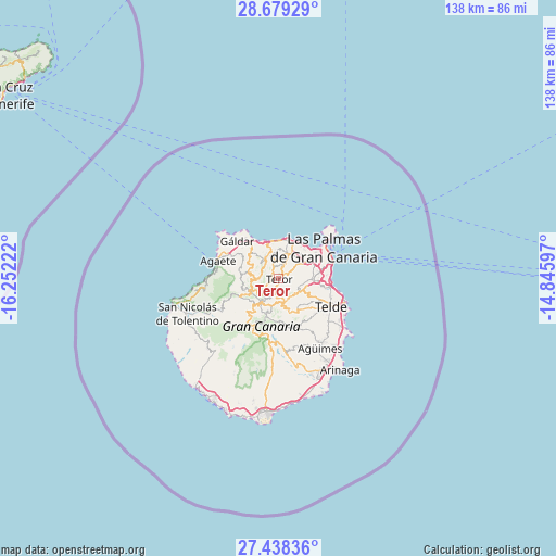
Teror GPS coordinates[2]
28° 3' 38.232" North, 15° 32' 56.724" West
| Map corner | latitude | longitude |
|---|---|---|
| Upper-left | 28.67929°, | -16.25222° |
| Center: | 28.06062°, | -15.54909° |
| Lower-right: | 27.43836°, | -14.84597° |
| Map W x H: | 138×138 km | = 85.7×85.7mi |
| max Lat: | 43.74134° ⇑99.6% North |
| Teror: | 28.06062° |
| min Lat: | ⇓0.4% South 27.64134° |
| min Long | Teror | max Long |
| -18.00367° | -15.54909° | 4.2899° |
| W 1.1%⇐ | ⇒98.9% E |
Elevation
Elevation of Teror is 634 m = 2080 ft, and this is 36 m = 118 ft above average elevation for this country.
| Max E: |
1682 m = 5518 ft | 52.2% |
| Teror | 634 m 2080 ft | |
| Avg. | 598 m = 1962 ft | |
Min E: |
0 m = 0 ft | 47.8% |
See also: Spain elevation on elevation.city.
Geographical zone
Teror is located in North temperate zone (between Tropic of Cancer and the Arctic Circle). Distance of this Northern Tropic circle is 514.1 km =319.4 mi to South.| Distance of | km | miles | from Teror |
|---|---|---|---|
| North Pole | 6887 | 4279.4 | to North |
| Arctic Circle | 4281.1 | 2660.2 | to North |
| Tropic Cancer | 514.1 | 319.4 | to South |
| Equator | 3120 | 1938.7 | to South |


Nearby cities:
15 places around Teror: (largest is in red/bold)
• Agaete
15.4 km =9.6 mi,  286°
286°
• Artenara
10.6 km =6.6 mi,  245°
245°
• Arucas
7.1 km =4.4 mi,  21°
21°
• Firgas
5.3 km =3.3 mi,  345°
345°
• Guia
12 km =7.5 mi,  316°
316°
• Gáldar
13.8 km =8.6 mi,  314°
314°
• Las Palmas de Gran Canaria
14 km =8.7 mi,  71°
71°
• Moya
6.5 km =4 mi,  329°
329°
• San Bartolomé de Tirajana
15.3 km =9.5 mi,  188°
188°
• Santa Brígida
5.4 km =3.4 mi,  125°
125°
• Tejeda
9.8 km =6.1 mi,  221°
221°
• Telde
14.8 km =9.2 mi,  120°
120°
• Valleseco
3.3 km =2.1 mi,  234°
234°
• Valsequillo de Gran Canaria
9.8 km =6.1 mi,  148°
148°
• Vega de San Mateo
6 km =3.7 mi,  164°
164°
Sources, notices
• [Note1] Compared only with cities in Spain existing in our database
• [Src1] Map data: © OpenStreetMap contributors (CC-BY-SA)
• [Src2] Other city data from geonames.org with taken over terms of usage.
• [Src3] Geographical zone / Annual Mean Temperature by Robert A. Rohde @ Wikipedia
