Cruce de Arinaga geodata
Cruce de Arinaga (Canary Islands) is a populated locality; located in Spain in Atlantic/Canary (GMT+1) time zone. With population of 2,700 people, there are 1817 cities with bigger population in this country. Compared to other cities in Spain, 99.9% of cities are located further ↑North; 98.8% of cities are located further →East and 89.5% of cities have higher elevation than Cruce de Arinaga. Note1
Administrative division(s):
- Level 1: Canary Islands
- Level 2: Provincia de Las Palmas
- Level 3: Agüimes


Cruce de Arinaga GPS coordinates[2]
27° 52' 35.616" North, 15° 25' 40.728" West
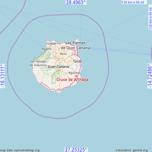
| Map corner | latitude | longitude |
|---|---|---|
| Upper-left | 28.4963°, | -16.13111° |
| Center: | 27.87656°, | -15.42798° |
| Lower-right: | 27.25325°, | -14.72486° |
| Map W x H: | 138.2×138.2 km | = 85.9×85.9mi |
| max Lat: | 43.74134° ⇑99.9% North |
| Cruce de Arinaga: | 27.87656° |
| min Lat: | ⇓0.1% South 27.64134° |
| min Long | Cruce de Arinag | max Long |
| -18.00367° | -15.42798° | 4.2899° |
| W 1.2%⇐ | ⇒98.8% E |
Elevation
Elevation of Cruce de Arinaga is 75 m = 246 ft, and this is 523 m = 1716 ft below average elevation for this country.
| Max E: |
1682 m = 5518 ft | 89.5% |
| Avg. | 598 m = 1962 ft | |
| Cruce de Arinaga | 75 m = 246 ft | |
Min E: |
0 m = 0 ft | 10.5% |
See also: Spain elevation on elevation.city.
Geographical zone
Cruce de Arinaga is located in North temperate zone (between Tropic of Cancer and the Arctic Circle). Distance of this Northern Tropic circle is 493.7 km =306.8 mi to South.| Distance of | km | miles | from Cruce de Arinaga |
|---|---|---|---|
| North Pole | 6907.5 | 4292.1 | to North |
| Arctic Circle | 4301.6 | 2672.9 | to North |
| Tropic Cancer | 493.7 | 306.8 | to South |
| Equator | 3099.6 | 1926 | to South |


Nearby cities:
15 places around Cruce de Arinaga: (largest is in red/bold)
• Agüimes
3.7 km =2.3 mi,  330°
330°
• Carrizal
4.5 km =2.8 mi,  29°
29°
• Ingenio
4.7 km =2.9 mi,  352°
352°
• Maspalomas
20.2 km =12.6 mi,  230°
230°
• Playa del Ingles
19.9 km =12.4 mi, 228°
• San Bartolomé de Tirajana
15.3 km =9.5 mi,  290°
290°
• Santa Brígida
18.8 km =11.7 mi,  336°
336°
• Santa Lucía
11.7 km =7.3 mi, 289°
• Tejeda
22.6 km =14 mi,  305°
305°
• Telde
12.9 km =8 mi,  3°
3°
• Teror
23.7 km =14.7 mi, 329°
• Valleseco
23.6 km =14.7 mi,  321°
321°
• Valsequillo de Gran Canaria
13.9 km =8.6 mi, 330°
• Vecindario
3.7 km =2.3 mi,  205°
205°
• Vega de San Mateo
18 km =11.2 mi, 324°
Sources, notices
• [Note1] Compared only with cities in Spain existing in our database
• [Src1] Map data: © OpenStreetMap contributors (CC-BY-SA)
• [Src2] Other city data from geonames.org with taken over terms of usage.
• [Src3] Geographical zone / Annual Mean Temperature by Robert A. Rohde @ Wikipedia
