Santanyí geodata
Santanyí (Balearic Islands) is a seat of a third-order administrative division; located in Spain in Europe/Madrid (GMT+2) time zone. With population of 12,664 people, there are 721 cities with bigger population in this country. Compared to other cities in Spain, 78.2% of cities are located further ↑North; 99.5% of cities are located further ←West and 90.1% of cities have higher elevation than Santanyí. Note1


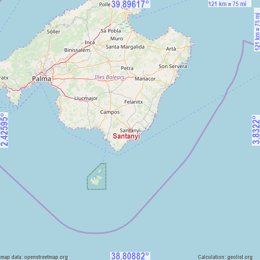
Santanyí GPS coordinates[2]
39° 21' 16.596" North, 3° 7' 44.652" East
| Map corner | latitude | longitude |
|---|---|---|
| Upper-left | 39.89617°, | 2.42595° |
| Center: | 39.35461°, | 3.12907° |
| Lower-right: | 38.80882°, | 3.8322° |
| Map W x H: | 120.9×120.9 km | = 75.1×75.1mi |
| max Lat: | 43.74134° ⇑78.2% North |
| Santanyí: | 39.35461° |
| min Lat: | ⇓21.8% South 27.64134° |
| min Long | Santanyí | max Long |
| -18.00367° | 3.12907° | 4.2899° |
| W 99.5%⇐ | ⇒0.5% E |
Elevation
Elevation of Santanyí is 65 m = 213 ft, and this is 533 m = 1749 ft below average elevation for this country.
| Max E: |
1682 m = 5518 ft | 90.1% |
| Avg. | 598 m = 1962 ft | |
| Santanyí | 65 m = 213 ft | |
Min E: |
0 m = 0 ft | 9.9% |
See also: Spain elevation on elevation.city.
Geographical zone
Santanyí is located in North temperate zone (between Tropic of Cancer and the Arctic Circle). Distance of this Northern Tropic circle is 1769.9 km =1099.8 mi to South.| Distance of | km | miles | from Santanyí |
|---|---|---|---|
| North Pole | 5631.2 | 3499.1 | to North |
| Arctic Circle | 3025.4 | 1879.9 | to North |
| Tropic Cancer | 1769.9 | 1099.8 | to South |
| Equator | 4375.8 | 2719 | to South |


Nearby cities:
15 places around Santanyí: (largest is in red/bold)
• Cala d'Or
9.5 km =5.9 mi,  73°
73°
• Calonge
8.2 km =5.1 mi,  51°
51°
• Campos
12.7 km =7.9 mi,  312°
312°
• Colònia de Sant Jordi
12.5 km =7.8 mi,  251°
251°
• Felanitx
12.9 km =8 mi,  7°
7°
• Llucmajor
25.4 km =15.8 mi, 306°
• Manacor
24.9 km =15.5 mi,  16°
16°
• Montuïri
26.8 km =16.7 mi,  331°
331°
• Porreres
20 km =12.4 mi, 332°
• Porto Cristo
27 km =16.8 mi,  40°
40°
• Portocolom
12.9 km =8 mi,  58°
58°
• Sa Ràpita
16.1 km =10 mi,  274°
274°
• Sant Joan
27.9 km =17.3 mi,  343°
343°
• Ses Salines
6.8 km =4.2 mi, 254°
• Vilafranca de Bonany
24.1 km =15 mi,  351°
351°
Sources, notices
• [Note1] Compared only with cities in Spain existing in our database
• [Src1] Map data: © OpenStreetMap contributors (CC-BY-SA)
• [Src2] Other city data from geonames.org with taken over terms of usage.
• [Src3] Geographical zone / Annual Mean Temperature by Robert A. Rohde @ Wikipedia
