Portocolom geodata
Portocolom (Balearic Islands) is a populated place; located in Spain in Europe/Madrid (GMT+2) time zone. With population of 4,586 people, there are 1374 cities with bigger population in this country. Compared to other cities in Spain, 77.7% of cities are located further ↑North; 99.8% of cities are located further ←West and 100% of cities have higher elevation than Portocolom. Note1


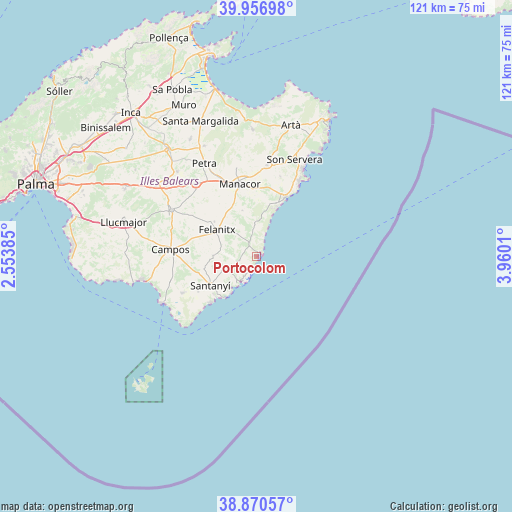
Portocolom GPS coordinates[2]
39° 24' 57.204" North, 3° 15' 25.092" East
| Map corner | latitude | longitude |
|---|---|---|
| Upper-left | 39.95698°, | 2.55385° |
| Center: | 39.41589°, | 3.25697° |
| Lower-right: | 38.87057°, | 3.9601° |
| Map W x H: | 120.8×120.8 km | = 75.1×75.1mi |
| max Lat: | 43.74134° ⇑77.7% North |
| Portocolom: | 39.41589° |
| min Lat: | ⇓22.3% South 27.64134° |
| min Long | Portocolom | max Long |
| -18.00367° | 3.25697° | 4.2899° |
| W 99.8%⇐ | ⇒0.2% E |
Elevation
Elevation of Portocolom is 1 m = 3 ft, and this is 597 m = 1959 ft below average elevation for this country.
| Max E: |
1682 m = 5518 ft | 100% |
| Avg. | 598 m = 1962 ft | |
| Portocolom | 1 m = 3 ft | |
Min E: |
0 m = 0 ft | 0% |
See also: Spain elevation on elevation.city.
Geographical zone
Portocolom is located in North temperate zone (between Tropic of Cancer and the Arctic Circle). Distance of this Northern Tropic circle is 1776.7 km =1104 mi to South.| Distance of | km | miles | from Portocolom |
|---|---|---|---|
| North Pole | 5624.4 | 3494.8 | to North |
| Arctic Circle | 3018.5 | 1875.6 | to North |
| Tropic Cancer | 1776.7 | 1104 | to South |
| Equator | 4382.6 | 2723.2 | to South |


Nearby cities:
15 places around Portocolom: (largest is in red/bold)
• Cala d'Or
4.6 km =2.9 mi,  204°
204°
• Calonge
4.9 km =3 mi,  249°
249°
• Campos
20.5 km =12.7 mi,  274°
274°
• Colònia de Sant Jordi
25.2 km =15.7 mi,  244°
244°
• Felanitx
11.1 km =6.9 mi,  302°
302°
• Manacor
17.6 km =10.9 mi,  346°
346°
• Petra
25.2 km =15.7 mi,  330°
330°
• Porreres
23 km =14.3 mi, 298°
• Porto Cristo
15.2 km =9.4 mi,  25°
25°
• Sant Joan
27.4 km =17 mi,  317°
317°
• Sant Llorenç des Cardassar
21.7 km =13.5 mi,  6°
6°
• Santanyí
12.9 km =8 mi, 238°
• Ses Salines
19.6 km =12.2 mi, 243°
• Son Servera
24.4 km =15.2 mi,  21°
21°
• Vilafranca de Bonany
22.3 km =13.9 mi, 319°
Sources, notices
• [Note1] Compared only with cities in Spain existing in our database
• [Src1] Map data: © OpenStreetMap contributors (CC-BY-SA)
• [Src2] Other city data from geonames.org with taken over terms of usage.
• [Src3] Geographical zone / Annual Mean Temperature by Robert A. Rohde @ Wikipedia
