Felanitx geodata
Felanitx (Balearic Islands) is a seat of a third-order administrative division; located in Spain in Europe/Madrid (GMT+2) time zone. With population of 18,270 people, there are 512 cities with bigger population in this country. Compared to other cities in Spain, 77.2% of cities are located further ↑North; 99.6% of cities are located further ←West and 86.5% of cities have higher elevation than Felanitx. Note1


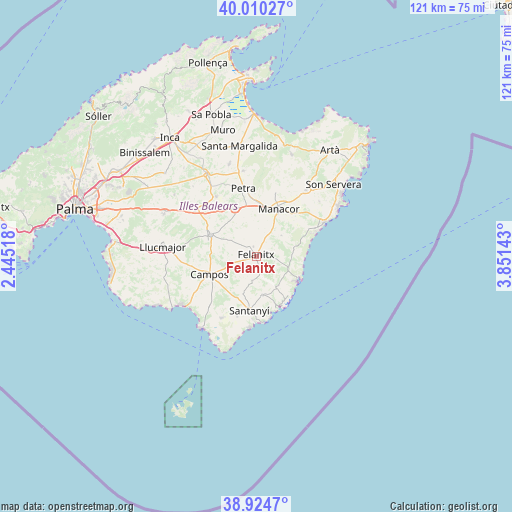
Felanitx GPS coordinates[2]
39° 28' 10.56" North, 3° 8' 53.916" East
| Map corner | latitude | longitude |
|---|---|---|
| Upper-left | 40.01027°, | 2.44518° |
| Center: | 39.4696°, | 3.14831° |
| Lower-right: | 38.9247°, | 3.85143° |
| Map W x H: | 120.7×120.7 km | = 75×75mi |
| max Lat: | 43.74134° ⇑77.2% North |
| Felanitx: | 39.4696° |
| min Lat: | ⇓22.8% South 27.64134° |
| min Long | Felanitx | max Long |
| -18.00367° | 3.14831° | 4.2899° |
| W 99.6%⇐ | ⇒0.40000000000001% E |
Elevation
Elevation of Felanitx is 116 m = 381 ft, and this is 482 m = 1581 ft below average elevation for this country.
| Max E: |
1682 m = 5518 ft | 86.5% |
| Avg. | 598 m = 1962 ft | |
| Felanitx | 116 m = 381 ft | |
Min E: |
0 m = 0 ft | 13.5% |
See also: Spain elevation on elevation.city.
Geographical zone
Felanitx is located in North temperate zone (between Tropic of Cancer and the Arctic Circle). Distance of this Northern Tropic circle is 1782.7 km =1107.7 mi to South.| Distance of | km | miles | from Felanitx |
|---|---|---|---|
| North Pole | 5618.5 | 3491.2 | to North |
| Arctic Circle | 3012.6 | 1871.9 | to North |
| Tropic Cancer | 1782.7 | 1107.7 | to South |
| Equator | 4388.6 | 2726.9 | to South |


Nearby cities:
15 places around Felanitx: (largest is in red/bold)
• Ariany
20.4 km =12.7 mi,  350°
350°
• Cala d'Or
12.6 km =7.8 mi,  143°
143°
• Calonge
9 km =5.6 mi,  148°
148°
• Campos
11.9 km =7.4 mi,  248°
248°
• Manacor
12.3 km =7.6 mi,  25°
25°
• Montuïri
17.9 km =11.1 mi,  307°
307°
• Petra
16.3 km =10.1 mi, 349°
• Porreres
11.9 km =7.4 mi,  294°
294°
• Porto Cristo
17.7 km =11 mi,  63°
63°
• Portocolom
11.1 km =6.9 mi,  122°
122°
• Sant Joan
16.9 km =10.5 mi,  326°
326°
• Sant Llorenç des Cardassar
19.5 km =12.1 mi,  36°
36°
• Santanyí
12.9 km =8 mi,  187°
187°
• Ses Salines
16.7 km =10.4 mi,  209°
209°
• Vilafranca de Bonany
12.2 km =7.6 mi, 334°
Sources, notices
• [Note1] Compared only with cities in Spain existing in our database
• [Src1] Map data: © OpenStreetMap contributors (CC-BY-SA)
• [Src2] Other city data from geonames.org with taken over terms of usage.
• [Src3] Geographical zone / Annual Mean Temperature by Robert A. Rohde @ Wikipedia
